


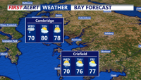
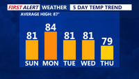
High pressure will keep Delmarva dry and mild through the weekend, with sunshine and highs in the 70s and 80s. Conditions begin to shift by Tuesday as a cold front approaches, bringing clouds, scattered showers, and cooler air by midweek.
From
To

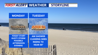
Showers and breezy winds will linger early Wednesday in Sussex County before conditions clear and remain dry into Friday morning.

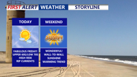
Sunday on Delmarva will bring bright, sunny skies, light winds and comfortable humidity as highs climb into the low to mid 80s. Overnight lows will drop into the upper 50s to low 60s under clear skies. While most of the week remains dry due to high pressure, beachgoers should remain cautious with a high risk of rip currents and waves reaching three to five fee

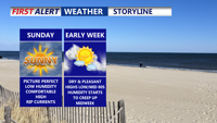
Sunday on Delmarva will bring sunny skies, light winds and comfortable conditions with highs in the upper 70s to low 80s. Humidity will stay low, making for a pleasant day outdoors, but beachgoers should be aware of a high risk for rip currents with waves between three and five feet. Sunday night will be cool and clear, with lows in the upper 50s to low 60s. High pressure remains in control into early next week before gradually shifting offshore midweek. Some moisture from a southern system could move into the region later in the week, but most areas will stay dry.


Delmarva enters Saturday night under cool, partly cloudy skies with west-northwest breezes and lows dipping into the upper 40s to low 50s. Sunday and Memorial Day Monday will remain mostly dry and seasonably cool, though a slight chance of showers may brush the area Sunday night. As high pressure retreats midweek, a more unsettled pattern will bring increasing rain chances beginning Tuesday night through late week.


High pressure will bring warm, dry weather to Delmarva on Sunday for Mother’s Day, with highs nearing the low 80s. Cloud cover increases Monday as a low-pressure system approaches, leading to scattered showers by Monday night and Tuesday. Rain chances linger midweek before a warmer, unsettled pattern returns for the weekend.

A slow-moving upper-level system will bring rounds of showers and potential storms to Delmarva through midweek, followed by improving weather and cooler temperatures heading into the weekend. Monday and Tuesday will remain mild with highs in the 70s, but a late week cold front could trigger thunderstorms with damaging winds and hail before high pressure settles in by the weekend.


Delmarva will experience clear, cool conditions Sunday night with temperatures dipping into the 40s. As high pressure shifts eastward, a warm front will bring above-normal temperatures and breezy conditions through midweek. A cold front arrives by Wednesday, bringing a chance for showers before clearing out for a cooler, drier weekend.

Sussex County’s beach towns will experience clear skies and mild temperatures through Wednesday before a cold front arrives late Wednesday night, bringing rain and cooler conditions into early Thursday morning.

Onshore flow continues across Delmarva, maintaining mild temperatures and breezy conditions through Monday. High pressure will keep skies mostly clear with patchy fog in the mornings. A potential tropical system developing off the southeastern U.S. coast may bring increased rain chances by Tuesday into Wednesday, accompanied by rising humidity levels.