


DELMARVA -- Mother’s Day is shaping up to be a picture-perfect spring day across the Delmarva Peninsula, as high pressure returns and temperatures rise under mostly sunny skies. Happy Mother's Day to all the great mom's out there!

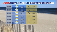
Looking at partly cloudy skies for your Mother's Day afternoon and highs in the low 80s.
A ridge of high pressure building in from the northwest will bring dry and warm conditions Sunday, with high temperatures climbing into the upper 70s to low 80s inland and mid to upper 70s along the coast. While some cirrus clouds may drift in—particularly across southern Delmarva—no rainfall is expected. Sunday night remains dry and seasonably mild, with lows settling in the mid-50s.
By Monday, the weather begins to change. An area of low pressure currently situated over the western Gulf Coast will gradually move northeast, sending more cloud cover into the region throughout the day. While Monday should stay dry across Delmarva, scattered showers are expected to develop late in the day, becoming more widespread Monday night into Tuesday.
Highs Monday will again reach the 70s to near 80 degrees, with cooler readings along coastal areas. Despite the incoming rain, the region is not expected to see a washout. Intermittent dry periods are likely, with total rainfall amounts through Tuesday around a half inch for parts of Delmarva.

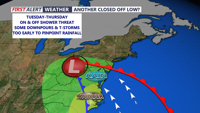
An unsettled stretch of weather develops Tuesday-Thursday.
The increased cloud cover and mild air moving north with the system will keep Monday night lows in the 50s across northern Delmarva and 60s farther south. Highs on Tuesday will trend cooler—closer to 70 degrees—as showers linger and sunshine remains limited. Due to stable southeasterly winds and overcast skies, the risk for thunderstorms Tuesday is low.
Rain chances remain elevated through Tuesday night and into Wednesday as the low transitions into a trough and moves closer to the Mid-Atlantic. While some instability could trigger a few rumbles of thunder late Tuesday or Wednesday, severe weather is not expected. Highs midweek will stay near 70, with the warmest readings likely in central Delmarva.
By Thursday, rain chances begin to diminish as the system exits, allowing for a few breaks of sun. Temperatures are expected to rise into the mid to upper 70s, and some inland areas could touch 80 degrees.
A brief period of drier weather may develop Thursday night, but another system—this time a closed low forming over the Great Lakes—is forecast to impact the region by Friday and Saturday. This next disturbance could bring scattered afternoon showers and thunderstorms to parts of Delmarva, particularly inland areas away from the coast. Highs both days will reach the low to mid-80s, and any cold fronts associated with the low could enhance thunderstorm activity as the weekend progresses.
