


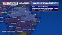
Today starts a much cooler stretch across Delmarva with mostly cloudy skies, highs in the mid 50s, and gusty winds. The biggest concern is tonight, when a widespread freeze is expected inland with a Freeze Warning in effect from midnight to 9 AM Tuesday. After a chilly Tuesday, temperatures rebound into the 60s and 70s by mid to late week before cooler weather and a better chance of rain return for the weekend.
From
To

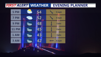
The chilly rain this afternoon will taper off late afternoon or early evening. Up to a quarter inch of rain is possible in some areas. Temperatures will be in the 40s and 50s.


Windy start to the week with a threat for severe weather later Monday.

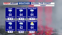
For the rest of Saturday afternoon and evening skies remain mostly cloudy skies with diminishing winds and temperatures in the 50s.

Dense fog is expected near the Delaware beaches late Wednesday, with mostly cloudy skies and occasional showers lingering through late Thursday.

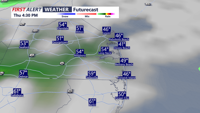
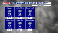
Low clouds, leftover fog and a few showers early Thursday give way to a damp, gray stretch into Friday morning.

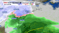
Rain and drizzle hang on early Friday, then taper as a mild, mostly cloudy pattern carries into early Saturday.

Rain and drizzle fade late tonight, then linger into Friday morning before a mostly cloudy, milder finish to the day.

Delmarva warms up today as a warm front lifts through, pushing highs into the mid to upper 40s with partly to mostly cloudy skies. A light southerly breeze increases tonight with a small chance of a stray sprinkle, but most spots stay dry and above freezing. Wednesday stays in the 40s but turns noticeably breezy ahead of a moisture-starved cold front. Cooler, breezy conditions follow Thursday and Friday, then Valentine’s Day kicks off the weekend with sunshine and a springlike feel. Late Sunday into early Monday, a storm system could bring precipitation—details still uncertain this far out.

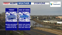
A bit warmer and breezy for the rest of Wednesday, then colder again to end the week. Some snow possible on Sunday.