


Today brings a return to seasonable temperatures across Delmarva with a mix of sun and clouds and highs in the low to mid 50s. Clouds increase tonight as high pressure slides offshore, with overnight lows holding in the mid to upper 40s. A cold front arrives late Thursday into Friday, bringing showers, gusty winds, and even a slight chance for thunder before cooler-than-normal air settles in for the weekend.
From
To

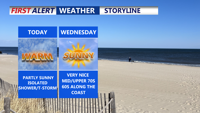
A gloomy, damp day continues across Delmarva with highs in the upper 40s to low 50s inland. Scattered showers and drizzle develop this evening and overnight with patchy fog and lows in the mid to upper 40s. Temperatures trend much warmer midweek into early next week (10–20° above average), though a back-and-forth front late week could create sharp north/south temperature differences and several chances for showers—plus a small thunder risk Thursday night.

A cold early Wednesday in Sussex County rebounds to the low-to-mid 40s with sunshine, then turns chilly again overnight into early Thursday.

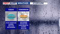
Wind chills in the teens will linger across Delmarva today before a short-lived warmup Thursday, we are watching a potentially impactful winter storm late Saturday through Sunday.

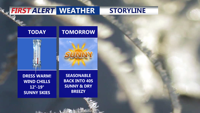
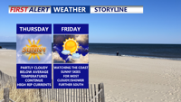
A cold night ahead with potential frost followed by a crisp, dry Friday under mostly sunny skies in Sussex County.

Delmarva enters a stretch of mild, mostly dry weather beginning Wednesday night, thanks to high pressure settling to the north and northeast. Although a weak coastal low may trigger a few isolated showers later this week, most areas will remain dry with gradually warming temperatures. Humidity will increase early next week, bringing hot conditions and a slight chance of showers and storms.

Sunday afternoon brings sunshine, cool temperatures, and breezy west winds across Delmarva. High pressure will dominate the region into midweek, leading to gradually warmer days and a potential return of summer heat by Thursday.

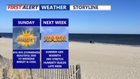
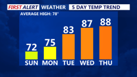
Sunday brings a refreshing start to June on Delmarva, with dry conditions, cool temperatures, and a light breeze. High pressure will dominate the region through midweek, setting the stage for a warming trend that could bring the first 90-degree day of the year by Thursday.

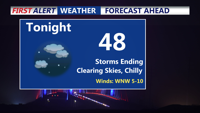
Storms have come to an end, clear and chilly night on tap as some areas away from the coast fall into the 40s. Bright, beautiful, breezy end to the weekend, summer-like next week as we make a run at our first 90 degree day of the year.

Patchy fog gives way to partly sunny skies and warm temperatures. A mix of isolated showers and storms will punctuate the rest of the week as multiple upper-level systems move through the region, bringing cooler temperatures and increased rain chances into the weekend.