


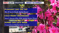
Delmarva will see a pleasant and mainly dry Tuesday with partly sunny skies and only a slight chance for an isolated shower or sprinkle. Temperatures will be mild inland, cooler along the coast, and partly cloudy skies continue tonight. Wednesday stays mild ahead of a strong cold front, with much-needed rain developing later in the day and continuing into early Thursday. A stronger thunderstorm cannot be ruled out, but the overall risk remains low.
From
To


Delmarva will see a mild start today with highs reaching the upper 60s to near 70 and just a slight chance for a light shower. Warmer-than-normal weather continues Thursday with temperatures climbing into the low to mid 70s, but a backdoor cold front brings cooler conditions Friday. The biggest weather change arrives this weekend, when a developing low pressure system is expected to spread widespread rain across the region along with much chillier temperatures.

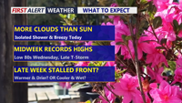
Delmarva starts the week on a warm and breezy note as a warm front lifts through the region, sending temperatures near 70 today and close to 80 Tuesday. Even warmer air builds in Wednesday, with record highs potentially challenged inland before a cold front brings the chance for afternoon and evening showers and thunderstorms. That front may stall nearby, keeping the weather unsettled through the weekend with periodic shower chances, but no day looks like a washout.


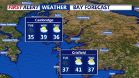
Today stays below average across Delmarva with partly sunny skies, highs in the upper 30s to low 40s, and a cold east-northeast wind off the ocean keeping conditions raw. Tonight turns partly cloudy with lows in the upper 20s to low 30s. The chill lingers Thursday before a warmer trend arrives Friday, the first day of spring, with highs near 60. Even warmer air builds in for the weekend, pushing temperatures into the 60s Saturday and low 70s inland Sunday before showers and cooler air return early next week.

Strong winds and cold temperatures persist Tuesday before easing overnight into early Wednesday in Sussex County.

A strong cold front ushers in damaging wind gusts and frigid temperatures through Tuesday evening in Sussex County.

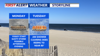
Saturday afternoon will kick off a stretch of warm and muggy weather across Delmarva, with partly sunny skies and highs in the 80s. While most of the region should stay dry this weekend, low clouds and patchy fog will return overnight, and a few isolated thunderstorms are possible Sunday over the Eastern Shore. By Monday, an approaching cold front will bring more widespread showers and storms. Temperatures will remain above normal into late next week, with heat indices potentially nearing 100 degrees.

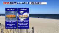
A stretch of warm and humid weather will settle over Delmarva through the weekend and into next week. Saturday and Sunday will bring partly sunny skies and temperatures climbing into the 80s, with low clouds and morning fog each day. While most of the region should stay dry through Sunday, a stronger cold front arriving late Monday is expected to trigger more widespread showers and thunderstorms. Highs will remain above normal all week, and heat indices may approach 100 degrees in some locations by midweek.

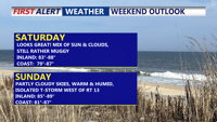
A persistent warm and muggy pattern will continue over Delmarva through early next week, bringing periods of low clouds and patchy fog overnight, with daytime highs in the 80s. While the weekend should remain mostly dry aside from isolated inland storms, a cold front approaching Monday will trigger more widespread showers and thunderstorms. Temperatures will stay above normal into midweek, with heat indices nearing 100 degrees in some locations.

A slow-moving upper-level system will bring rounds of showers and potential storms to Delmarva through midweek, followed by improving weather and cooler temperatures heading into the weekend. Monday and Tuesday will remain mild with highs in the 70s, but a late week cold front could trigger thunderstorms with damaging winds and hail before high pressure settles in by the weekend.