


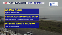
Delmarva has one more unsettled day ahead as a cold front approaches from the northwest. A Yellow Alert is in place for the threat of strong to severe thunderstorms this afternoon into early evening, with damaging wind gusts the main concern. Drier, more comfortable weather returns Thursday through the weekend.
From
To

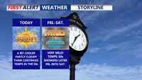
Delmarva will dry out this afternoon after morning showers, but rainfall totals were too light to make a meaningful dent in the ongoing severe drought. Breezy northwest winds and highs in the 60s will give way to a pleasant Friday, followed by a warmer, mostly dry weekend. By early next week, temperatures could climb into the upper 80s and low 90s before a cold front brings the next chance for storms around the middle of next week.

Delmarva will enjoy a sunny and comfortable day today with highs near 70 as high pressure settles in. Breezy and milder conditions arrive tonight into Wednesday, with temperatures climbing into the 70s before a cold front brings showers and a few possible thunderstorms Wednesday night into Thursday morning. After the system moves away, much warmer air builds in for the weekend and early next week, with widespread 80s and a few inland spots possibly reaching 90 by Monday.

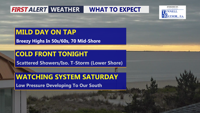
Delmarva will see a cloudy but mild day today, with highs ranging from the upper 50s and low 60s at the beaches to the mid and upper 60s inland, with a few spots on the Mid-Shore reaching near 70 degrees. A cold front arrives tonight, bringing scattered showers and an isolated thunderstorm before drier, breezy weather returns Thursday. The weekend remains uncertain, with a nearby storm system possibly bringing rain Saturday and chilly temperatures across the region.

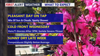
Delmarva will see a pleasant and mainly dry Tuesday with partly sunny skies and only a slight chance for an isolated shower or sprinkle. Temperatures will be mild inland, cooler along the coast, and partly cloudy skies continue tonight. Wednesday stays mild ahead of a strong cold front, with much-needed rain developing later in the day and continuing into early Thursday. A stronger thunderstorm cannot be ruled out, but the overall risk remains low.

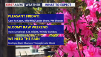
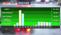
Delmarva will enjoy a pleasant Friday with partly cloudy skies, lighter northeast winds and cooler temperatures compared to Thursday. Temperatures will range from the low to mid 60s at the beaches to the 70s inland, with some lower shore communities nearing 80 degrees. A spotty shower is possible Friday evening into the overnight, but the bigger change arrives this weekend as low pressure brings widespread rain, chilly temperatures and breezy coastal conditions. Rainfall totals from Friday night through Sunday may reach half an inch to slightly over an inch inches across the area, providing beneficial rainfall despite the soggy weekend.


Near record warmth this afternoon, Easter Sunday becomes rainy with storms possible.

Today brings a return to seasonable temperatures across Delmarva with a mix of sun and clouds and highs in the low to mid 50s. Clouds increase tonight as high pressure slides offshore, with overnight lows holding in the mid to upper 40s. A cold front arrives late Thursday into Friday, bringing showers, gusty winds, and even a slight chance for thunder before cooler-than-normal air settles in for the weekend.

Sunshine and 50s hold on Thursday, then Delmarva jumps into the 60s Friday ahead of several rounds of rain Friday afternoon through Sunday morning.

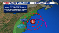
Delmarva is bracing for a powerful coastal storm expected to arrive late Saturday night, bringing heavy rain, strong winds, and significant coastal flooding through Monday. Sustained winds up to 40 mph and gusts near 60 mph+ along the coast, with widespread rainfall of 1 to 3 inches and higher amounts possible. The storm could lead to beach erosion, dune breaches, power outages, and dangerous coastal conditions before improving weather returns by Tuesday.