


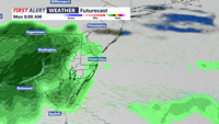
An expansive high-pressure system will dominate through Monday evening, with increasing onshore winds and clouds developing Tuesday through late evening in the Sussex County, Del. region.
From
To

High pressure moving in from Quebec will keep skies mostly clear and conditions dry through the weekend across the mid-Atlantic. Temperatures will gradually warm into the 70s and 80s before a cold front brings a chance of showers by Tuesday and Wednesday.

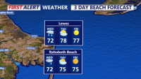
After a wet start Friday morning, Sussex County will see improving weather with mild temperatures and only spotty showers through early Sunday.

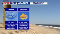
Showers and storms will taper off Friday morning in Sussex County as high pressure builds, bringing drier, seasonable weather into Saturday.

Sussex County will see periods of showers, breezy winds, and near-normal temperatures from late Tuesday into Thursday before conditions turn drier.

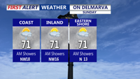
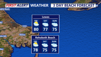
A stalled front and weak low pressure system will keep clouds and scattered showers over Delmarva Sunday, with highs only in the low to mid-70s. Conditions improve Sunday night as high pressure builds in, bringing dry and seasonable weather to start the week. A weak coastal low could bring more clouds midweek, while a warm, dry Thursday is followed by another cool and comfortable weekend.

Clouds and scattered showers linger across Delmarva Sunday as a nearly stationary front and weak low pressure system pass through the region. Highs will remain cool, in the low 70s, before conditions clear late in the day. Dry weather and seasonable temperatures return Sunday night into Monday, with partly sunny skies and highs in the mid-70s. A weak coastal low could increase cloud cover Tuesday into Wednesday, followed by a stretch of dry, pleasant weather for the latter half of the week.

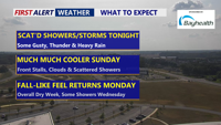
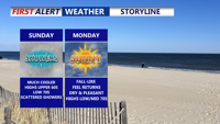
Scattered showers and thunderstorms will move across Delmarva Saturday evening, with the severe threat ending after 9 p.m. Some storms could still bring gusty winds, heavy rainfall, and localized flash flooding before overnight lows dip into the low to mid-60s. Much cooler air arrives Sunday as highs hold in the 60s, with a stalled front keeping scattered showers in the forecast. Skies will clear Sunday night, with lows in the mid-50s. Sunshine returns Monday with pleasant highs in the low to mid-70s, though clouds will increase Monday night as a weak coastal low approaches.

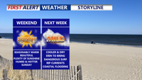
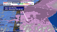
Delmarva will enjoy a warm but not overly hot Saturday, with highs in the 80s inland and 70s to low 80s along the coast. Humidity will remain elevated ahead of a Sunday cold front, which could bring an isolated shower late Sunday-early Monday. Cooler, drier conditions are expected early next week, we continue to monitor Hurricane Erin for possible coastal impacts starting Monday.

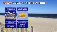
Delmarva will see scattered showers and storms this weekend, with the highest rain chances Saturday and a risk for stronger storms Sunday. Highs will reach the 80s and 90s before cooler, drier air moves in Sunday night. Early next week looks pleasant with sunshine and lower humidity, before warmer, stormier weather returns midweek.