


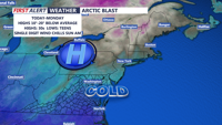
The dangerous cold stretch continues for Delmarva for the rest of the weekend and into the start of the new week.
From
To

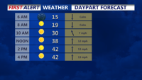
Tonight brings yet another frigid, frosty night across the peninsula. Temperatures will tumble into the single digits, ranging from about 4 to 12 degrees by daybreak Saturday.

Sussex County is set for a sharp drop to around 9 degrees Tuesday night, then a sunnier, less harsh Wednesday with highs reaching the 30s and low 40s — warmest near the coast.

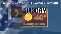
A sunny and chilly MLK Day, then back into the deep freeze.

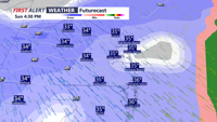
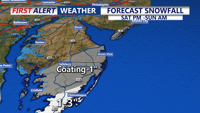
Rain changes to snow Sunday with light accumulations, then bitterly cold air follows into early next week.

Snow is expected to develop early Sunday morning and continue through late Sunday morning. Accumulations are expected to be in the 1-3" range, with slick roads Sunday morning.

We'll melt some snow the next couple of days as temperatures warm a bit. A few showers possible Saturday, with a chance of accumulating snow on Sunday. Then brutally cold air for next week.

The arctic air is in place for a couple of more days. Then warming temperatures into the weekend with showers possible Saturday and Sunday, even snow later on Sunday is possible.

Very cold temperatures and wind chills continue the rest of the week for Delmarva, with another chance of snow on Saturday.

A strong Canadian high-pressure system will usher in frigid temperatures and windy conditions starting today and lasting through Monday. Wind chills will dip into the 20s today, with even colder conditions expected Sunday morning. A potential low-pressure system could bring precipitation Monday night into Christmas Eve.