


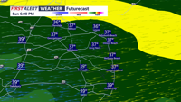
Low pressure slides to our south late Sunday into early Monday morning bringing a soaking rain.
From
To

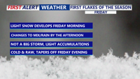
Colder-than-normal temperatures have settled across Delmarva, with highs ranging from the mid-30s to low 40s. The chill deepens by Thursday and into the weekend, as an arctic cold front approaches. While light snow is possible Friday, more impactful snow squalls and dangerously cold wind chills are expected Friday night into Saturday. Gusty winds behind the front may reach 50 mph, especially near the coast.

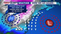
An arctic front sweeping across Delmarva today will usher in sharply colder air, strong northwest winds, and a chance for light snow and mix precipitation Friday before a reinforcing cold shot arrives late Sunday.

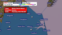
A winter storm watch is in effect for Sussex County, Delaware, and Ocean City, Maryland, from late Wednesday night through Thursday afternoon. Light snow accumulations, gusty winds, and cold temperatures are expected as a coastal low develops offshore.


A brief brush with winter weather starting this afternoon as a low-pressure system tracks northward. Rain will transition to sleet and snow by evening, though accumulation will remain light across most of the region. Following the system’s passage, an arctic cold front will plunge temperatures into the single digits by Monday night, bringing dangerously cold wind chills and potential hazards for residents and infrastructure.

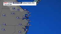
Delmarva braces for a frigid night, with wind chills in the single digits and light snow expected Friday night into Saturday morning. Accumulations will vary from 1-3 inches across much of the peninsula to up to 5 inches in parts of Accomack County. Gusty winds and icy roads pose hazards, while below-average temperatures persist into next week.

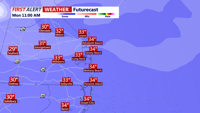
Delmarva is currently experiencing heavy snowfall, with rates of 1 to 2 inches per hour. The snow will continue through the morning, before a brief lull this afternoon, followed by another round of snow this evening. Early snowfall reports show 3-6 inches already on the ground in many areas. Travel today is not recommended as roads are covered in snow, and conditions will continue to worsen.

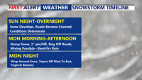
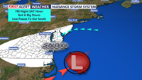
Sunny skies this morning, but frigid wind chills and gusty winds will make it feel like the teens. Clouds will increase late Sunday ahead of an overnight snowstorm that could bring 4 to 10 inches of snow to the region. Snow may mix with sleet or freezing rain along the southern coast, with blowing and drifting snow expected Monday night into Tuesday as winds intensify.


Delmarva will endure frigid temperatures tonight as Arctic high pressure builds over the region, with lows dipping into the lower 20s and wind chills plummeting into the teens. A Winter Storm Watch is in effect for Monday through early Tuesday, with 4 to as much as 10 inches of snow expected across the area. Bitter cold and gusty winds will linger through the week.

Bitter cold conditions will grip Sussex County through Saturday night and Sunday, with lows in the teens and highs struggling to reach the mid-30s. Forecasters are monitoring a potential snowstorm expected to impact the area late Sunday night into Monday.