


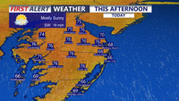
Delmarva will enjoy a mostly sunny and breezy day today with highs in the mid 70s and strong southerly gusts up to 35 to 40 mph. Showers arrive late this evening and continue overnight, with a few isolated thunderstorms possible, though severe weather is not expected. A brief unsettled stretch gives way to warmer, drier conditions by the weekend, with heat building into early next week.
From
To

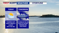
Delmarva warms up today as a warm front lifts through, pushing highs into the mid to upper 40s with partly to mostly cloudy skies. A light southerly breeze increases tonight with a small chance of a stray sprinkle, but most spots stay dry and above freezing. Wednesday stays in the 40s but turns noticeably breezy ahead of a moisture-starved cold front. Cooler, breezy conditions follow Thursday and Friday, then Valentine’s Day kicks off the weekend with sunshine and a springlike feel. Late Sunday into early Monday, a storm system could bring precipitation—details still uncertain this far out.

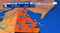
A warmer and sunnier stretch of weather is expected to return to Sussex County midweek, though a stray shower may develop late Tuesday.

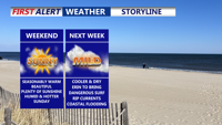
Delmarva will enjoy a warm but not overly hot Saturday, with highs in the 80s inland and 70s to low 80s along the coast. Humidity will remain elevated ahead of a Sunday cold front, which could bring an isolated shower late Sunday-early Monday. Cooler, drier conditions are expected early next week, we continue to monitor Hurricane Erin for possible coastal impacts starting Monday.

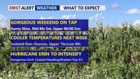
Delmarva will see a seasonably warm weekend as a stationary cold front lingers over the Mid-Atlantic. A few isolated showers and thunderstorms are possible Sunday evening before drier, cooler air settles in early next week. We continue to monitor Hurricane Erin, which could bring rough surf, dangerous rip currents, and minor coastal flooding to the region starting Monday.

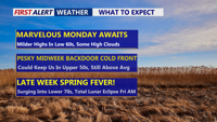
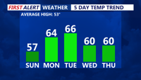
Delmarva will see a stretch of dry and mild weather beginning Monday, with sunshine and highs in the low to mid-60s inland and 50s along the coast. Southwest winds will push temperatures even higher Tuesday before a midweek cooldown. A backdoor cold front will briefly lower temperatures Wednesday before shifting north again, allowing a warming trend into the weekend. Highs could reach the low 70s by Saturday, with rain chances returning Sunday night.

Delmarva will experience clear and chilly conditions Sunday night, with lows in the mid-30s. A warming trend kicks off Monday, with highs reaching the low to mid-60s under mostly sunny skies. A stronger low will move in Monday night into Tuesday, lifting a warm front northward. By Tuesday, temperatures will climb further into the 60s, though a backdoor cold front could bring midweek uncertainty. A high-pressure system will briefly cool things down Wednesday before warmer air returns later in the week. By Saturday, highs could push into the upper 60s to low 70s.


Delmarva will see sunny but breezy conditions Sunday, with highs in the mid to upper 50s and gusts up to 30 mph, raising fire concerns. A warming trend begins Monday, with highs reaching the low to mid-60s under mostly sunny skies. Temperatures climb further Tuesday, but a backdoor cold front could limit Wednesday’s warmth. By Thursday, temperatures rebound into the 50s and 60s, with a continued warm stretch into the weekend. Highs could reach the upper 60s to low 70s by Saturday.

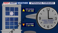
A cold and clear Saturday night will bring temperatures down into the 20s across Delmarva, but warmer days are ahead. Don't forget to set those clocks ahead an hour tonight. Sunday remains breezy with highs in the 50s, followed by a gradual warming trend through the week. By midweek, highs will reach the 60s, with temperatures possibly touching the low 70s by next Saturday.

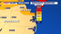
Delmarva has experienced an active winter with multiple snowfall events, yet the peninsula remains in a drought that’s slowly easing. Tonight, expect dry, partly cloudy skies and mild lows. A sensational Sunday awaits with seasonable highs in the upper 40s, as high pressure dominates the weekend. Early next week brings a warming trend into the 50s and low 60s before a series of cold fronts introduce chances for rain—and even a few snowflakes in the northern and northwestern areas—by Thursday. Fair weather is forecast for later Friday into early next weekend.