


DELMARVA -- A stationary cold front will linger over the Mid-Atlantic through the weekend, keeping Delmarva in a pattern of humid but relatively comfortable weather. High pressure from the Canadian Maritimes will build southward Saturday before moving offshore Sunday, allowing another cold front to approach from Canada.
Tonight, any lingering showers or thunderstorms on the Eastern Shore will taper off by sunset. Low clouds will spread in from the ocean overnight, and with light winds, patchy fog could develop across the region. Overnight lows will fall into the low 70s.

Mostly sunny Saturday, highs upper 70s to low 80s, LOW rip current risk for DE Beaches, MODERATE risk for Ocean City to Chincoteague.
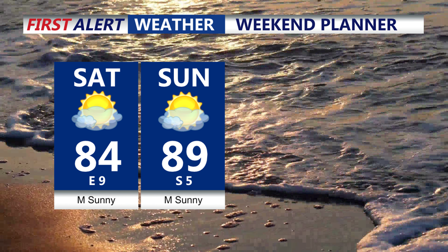
Onshore flow will keep temperatures in check, with highs reaching the mid to upper 80s inland and the upper 70s to low 80s at the coast under mostly sunny skies. Dew points will remain high, in the upper 60s to low 70s, keeping humidity levels elevated.

Mostly sunny weekend on Delmarva, mid 80s Saturday, bit warmer Sunday.
High pressure will shift toward New England Saturday night, bringing cooler and drier conditions with lows in the 60s to near 70.

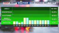
Possible isolated showers/storms Monday, then again on Wednesday.
By Sunday, the high will move offshore, and southerly winds will boost temperatures into the upper 80s to near 90. Humidity will rise again, and a passing cold front late Sunday afternoon into the evening could trigger scattered showers and thunderstorms. However, coverage is expected to be limited, and the risk for severe weather or flooding remains low. Lows Sunday night will dip into the 60s to near 70.
The cold front will stall over the Mid-Atlantic early in the week, with high pressure ridging in from the north and east. Onshore flow Monday and Tuesday will usher in a cooler airmass, keeping highs in the 70s to low 80s Monday and even cooler Tuesday. Another upper-level disturbance could bring showers and thunderstorms Tuesday night into Wednesday, with drier conditions expected Thursday and Friday.
WATCHING HURRICANE ERIN: We are continuing to closely track Hurricane Erin, currently well east of the Northern Leeward Islands. Erin will intensify into a major Category 4 hurricane late in the weekend. While direct impacts to Delmarva are uncertain, coastal effects are likely beginning Monday and continuing into Thursday, including a high risk for rip currents, dangerous surf, and the potential for minor coastal flooding.