


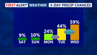
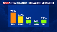
Delmarva will enjoy a pleasant Friday with partly cloudy skies, lighter northeast winds and cooler temperatures compared to Thursday. Temperatures will range from the low to mid 60s at the beaches to the 70s inland, with some lower shore communities nearing 80 degrees. A spotty shower is possible Friday evening into the overnight, but the bigger change arrives this weekend as low pressure brings widespread rain, chilly temperatures and breezy coastal conditions. Rainfall totals from Friday night through Sunday may reach half an inch to slightly over an inch inches across the area, providing beneficial rainfall despite the soggy weekend.
From
To


Heading into tonight, expect spotty showers and areas of drizzle to develop, especially farther north on Delmarva.

Sussex County will ride a mild stretch from late Friday through late Saturday evening, then brace for a colder pattern as an arctic front approaches late Saturday night into Sunday.

Winds ease overnight before a weak front ushers in cooler, breezy weather and possible isolated showers on Thursday.

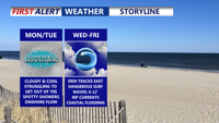
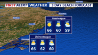
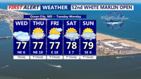
A stalled cold front south of Delmarva will bring sharply cooler, breezy conditions Monday, with highs only in the 70s under mostly cloudy skies with some showers possible. High pressure from the north will reinforce the cool pattern through midweek, while Hurricane Erin remains offshore but creates coastal hazards including high surf, rip currents, and possible flooding.

Mostly cloudy skies with mild temperatures and a small chance of spotty showers will continue through late Tuesday night and Wednesday as high pressure lingers to the north.

A rainy Sunday afternoon across Delmarva marks the start of a multi-day stretch of unsettled weather driven by a slow-moving upper-level low over the Ohio Valley. While conditions improve briefly midweek, another cold front and trough system may bring showers and cooler air back by Friday before high pressure builds in for the weekend.

High pressure will keep conditions mostly clear and dry Monday night, with clouds increasing by Tuesday morning as a warm front approaches. Expect slightly warmer temperatures and the chance of a few spotty showers, especially along coastal areas.

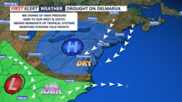
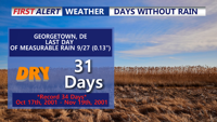
A sunny, dry weather pattern will persist over Delmarva, extending a 28-day streak without measurable rainfall. Friday brings clear skies and mild temperatures, but breezy conditions on Saturday may elevate fire weather risks. Little to no rain is expected from weak frontal systems this weekend, and high pressure will maintain dry conditions into next week. Temperatures will gradually warm, reaching the 70s by midweek.
Delmarva, including Coastal Sussex County, Cambridge, and Ocean City, will experience cooling temperatures and scattered showers through Friday, with a weak high pressure bringing some clearer skies and warmer weather by the end of the week.