


Sussex County will see dry, comfortable weather from early Saturday through early Sunday before storm chances increase Monday.
From
To


Sussex County can expect a calm, comfortable start to the weekend before unsettled weather returns Monday.

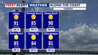
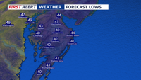
Sussex County will see a hot, humid Tuesday with inland highs in the 90s, cooler beach conditions and another unusually warm night into early Wednesday.


Hot, more humid weather will continue across Sussex County through Tuesday night, with inland areas facing near-record heat and peak heat index values close to 100 degrees.


Sussex County can expect a cooler Thursday with clouds, a few lingering showers early and another brief shower possible during the afternoon before drier weather settles in Thursday night.


Sussex County will stay dry, warm and windy from early Tuesday through early Wednesday, keeping fire concerns elevated before rain arrives later Wednesday into Thursday.


Sussex County will stay dry, breezy and fire-prone from late Monday night through Tuesday evening before showers bring some relief Wednesday night into Thursday.


Sussex County should stay mainly dry from early Tuesday through early Wednesday morning before rain chances increase later Wednesday.

A cold front is expected to bring widespread rain to Sussex County later Wednesday into early Thursday, with a low risk of stronger thunderstorms.


Light rain late Wednesday evening may briefly mix with snow early Thursday before temperatures fall and gusty winds usher in colder air.