


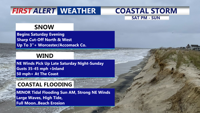
A bitter Arctic blast is locked over Delmarva today, with highs only in the low to mid 20s and wind chills feeling closer to the single digits. Cold Weather Advisories remain in effect for all of Delaware and the northern Mid-Shore through 10 AM Saturday, and a rapidly strengthening offshore storm this weekend will bring strong coastal winds (gusts near/above 50 mph) plus a limited snow threat mainly toward the southern half of the peninsula.
From
To

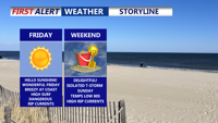
Delmarva will see sunshine and mild conditions today as high pressure settles over the region, but coastal flooding concerns linger with Hurricane Erin churning offshore. A warmer weekend leads into isolated chance of showers and thunderstorms Sunday, followed by cooler, drier weather next week.

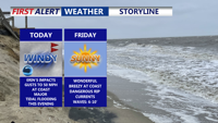
Hurricane Erin will make its closest pass to the Mid-Atlantic today, staying several hundred miles offshore but still delivering dangerous coastal conditions to Delaware and Maryland beaches. The storm is producing tropical-storm-force winds just off the coast, creating threats of beach erosion, life-threatening rip currents, and major tidal flooding along the Delaware shoreline. Conditions will improve tonight as Erin moves northeast, with fair and pleasant weather expected Friday and Saturday before another cold front brings unsettled conditions early next week.

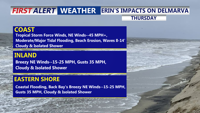
Hurricane Erin will pass offshore this week, but its growing size is already producing dangerous waves and life-threatening rip currents along Delmarva beaches. Tropical Storm Warnings remain in effect from the coastal waters of Cape Henlopen to Chincoteague, with strong winds and minor to moderate tidal flooding expected Thursday. Conditions begin to ease by Friday as high pressure builds in.


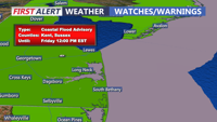
A sunny and breezy day kicks off the weekend across Delmarva, with temperatures slightly above normal for mid-November. However, brisk winds and high astronomical tides, aided by the full moon, will maintain minor coastal flooding concerns through the weekend. Overnight lows Saturday will drop near freezing inland, with warming temperatures expected Sunday into Monday. A weak cold front on Sunday night brings minimal impact, and above-average temperatures continue into early next week.

We're seeing a clearing trend and cool weather to end the week, with a dry and mild weekend. Some tidal flooding is possible into Saturday.

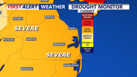
The latest drought monitor indicates the majority of Delmarva is still seeing severe drought conditions. Some relief tonight will showers overspreading the region.

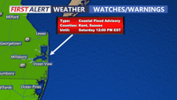
Chilly and increasingly cloudy today, followed by widespread minor coastal flooding starting with Thursday morning's high tide. A Coastal Flood Advisory remains in effect through Friday due to elevated astronomical tides from the full moon and persistent onshore winds. Rain is expected this evening into Friday morning, with up to a half an inch possible. By the weekend, drier air and milder temperatures in the 60s will settle in, but breezy conditions could persist.


This order empowers the Department of Emergency Management to coordinate state government preparations, offering an additional layer of protection for Marylanders without declaring a State of Emergency.