


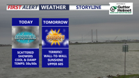
Delmarva will feel much cooler today, with temperatures running 25 to 30 degrees lower than yesterday. Scattered showers will taper off late this afternoon into the early evening, while gusty northeast winds make it feel raw. Sunshine returns Tuesday, followed by warmer, windier weather Wednesday with showers and a few thunderstorms possible. A drier and much warmer pattern is expected by the weekend, bringing a taste of summer with highs climbing into the upper 80s to low 90s.
From
To

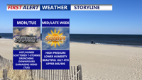
A stalled front lifting north will trigger rounds of thunderstorms across Delmarva starting Monday and lasting into Tuesday night. With temperatures climbing into the upper 80s to low 90s and abundant moisture, the atmosphere will become increasingly unstable. Forecast models point to a heightened risk of damaging wind gusts and localized flash flooding, especially Tuesday, when a Slight Risk for severe weather has been issued. Quieter and more pleasant weather is expected to settle in by midweek and continue through the Fourth of July holiday weekend.

A stalled front across Delmarva Sunday afternoon will keep heat and isolated storms in the forecast to start the week. By Tuesday, a stronger cold front brings the potential for severe thunderstorms. After midweek, high pressure settles in, leading to more comfortable conditions and pleasant weather just in time for the Fourth of July holiday weekend.

A stalled front over Delmarva Sunday will trigger heat and isolated storms to start the week. By Tuesday, a stronger cold front will bring the chance of severe thunderstorms. High pressure then builds in midweek, setting up lower humidity and comfortable weather heading into the Fourth of July holiday weekend.

A weak cold front moving into Delmarva Saturday night will stall and keep unsettled conditions through early next week. After a hot and humid Sunday, a warm front lifting north Monday will bring scattered storms and sweltering heat indices above 100 degrees inland. By Tuesday, a stronger cold front could trigger severe thunderstorms with damaging winds. Drier, more comfortable weather gradually arrives mid to late week, just in time for the Fourth of July weekend.

Sunday afternoon brings sunshine, cool temperatures, and breezy west winds across Delmarva. High pressure will dominate the region into midweek, leading to gradually warmer days and a potential return of summer heat by Thursday.

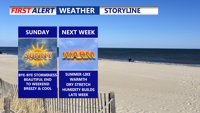
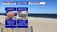
Sunday brings a refreshing start to June on Delmarva, with dry conditions, cool temperatures, and a light breeze. High pressure will dominate the region through midweek, setting the stage for a warming trend that could bring the first 90-degree day of the year by Thursday.

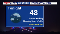
Storms have come to an end, clear and chilly night on tap as some areas away from the coast fall into the 40s. Bright, beautiful, breezy end to the weekend, summer-like next week as we make a run at our first 90 degree day of the year.

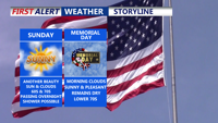
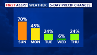
Sunday and Memorial Day will offer fair skies and seasonably cool temperatures across Delmarva, with high pressure in control. A slight chance of showers is possible late Sunday night. The dry pattern continues into Tuesday, before a more unsettled stretch begins midweek with increasing rain chances from Tuesday night through Friday.

A rainy Sunday afternoon across Delmarva marks the start of a multi-day stretch of unsettled weather driven by a slow-moving upper-level low over the Ohio Valley. While conditions improve briefly midweek, another cold front and trough system may bring showers and cooler air back by Friday before high pressure builds in for the weekend.