


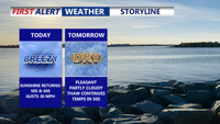
Mostly sunny skies and gusty winds rule Wednesday and Thursday, then temperatures jump above average Friday and Saturday with increasing chances for showers.
From
To

Clouds dominate Delmarva today as a warming trend develops ahead of several passing systems, bringing milder temperatures, periodic rain chances and a strong cold front by the weekend.

A gradual warmup Monday will continue into early Tuesday as clouds increase, with Sussex County remaining mostly dry.

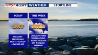
High pressure keeps Delmarva cold and mainly dry through the weekend, with only a slight chance of precipitation late Saturday night before milder air arrives by midweek.


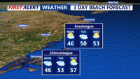
Drying out this afternoon and turning colder with temperatures falling from the 50s into the 40s.

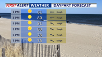
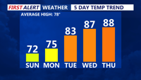
Delmarva will enjoy a sunny and comfortable Sunday, with highs in the upper 70s to low 80s and a moderate rip current risk from Delaware beaches through Chincoteague. Overnight lows will dip into the 50s inland and 60s at the coast. High pressure will weaken early next week, bringing a warming trend into the upper 80s and low 90s by Tuesday. Midweek turns hotter and more humid, with a surface trough and cold front increasing the chances for showers and storms Wednesday and Thursday. The front may stall into the weekend, keeping the forecast unsettled.


Delmarva will enjoy another sunny and comfortable day on Sunday, with highs in the upper 70s to low 80s — several degrees below normal for early August. A moderate rip current risk will remain in effect for Delaware beaches through Chincoteague, and swimmers are urged to stay near lifeguards. Overnight lows will dip into the 50s inland and 60s near the coast. High pressure will weaken early in the week, bringing a warming trend that pushes highs into the upper 80s to low 90s by Tuesday. Midweek turns hotter and more humid.


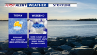
Unseasonably cool weather will stick around through the weekend, with sunny skies and below-average temperatures continuing Sunday. Overnight lows will dip into the 50s inland and 60s at the coast, with a moderate rip current risk from Delaware beaches to Chincoteague. A gradual warm-up begins early next week, leading into hotter and more humid conditions by midweek, with a chance of storms Wednesday and Thursday.


Sussex County will see dry, warm weather from Tuesday morning through early Thursday, with a shift toward higher temperatures and humidity by midweek.

Sunday afternoon brings sunshine, cool temperatures, and breezy west winds across Delmarva. High pressure will dominate the region into midweek, leading to gradually warmer days and a potential return of summer heat by Thursday.