


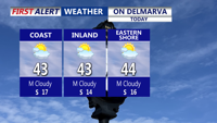


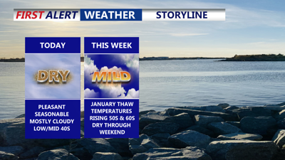
DELMARVA -- Cloudy skies will prevail across Delmarva today as high pressure shifts offshore and winds turn southerly, remaining light. Afternoon highs are expected to range from 41 to 46 degrees.

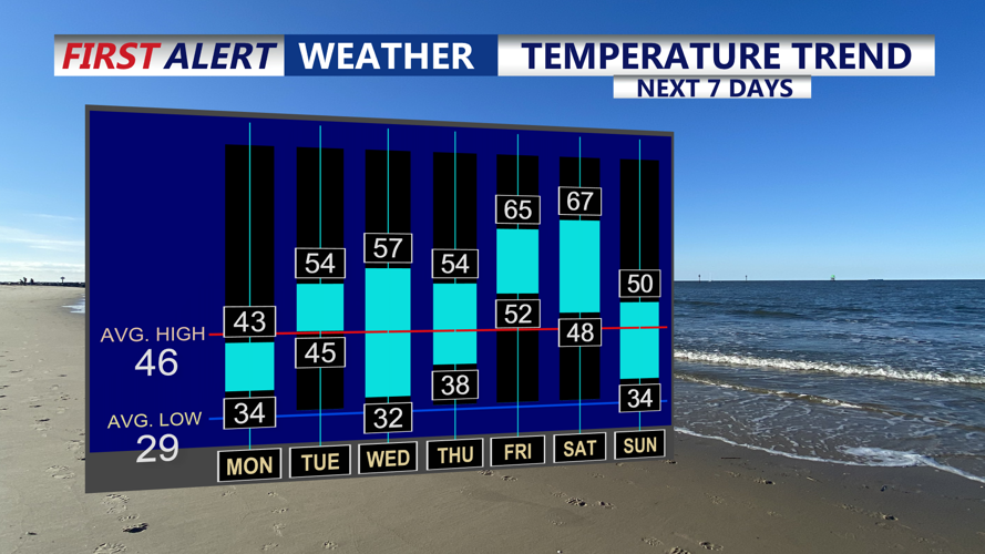
January thaw is heading our way this week as temperatures rise into the 50s and 60s.
Conditions remain dry tonight, though clouds will persist as warmer air continues to move in aloft. Temperatures will dip slightly but stay milder than recent mornings, with lows ranging from 32 to 36 degrees.

Mostly cloudy skies and highs 41 to 46, winds out of the south 5 to 15.
A milder air mass settles over Delmarva Tuesday into Wednesday as a low-pressure system tracks north of the region. Clouds will remain widespread, and while most precipitation is expected north of Delmarva. Highs Tuesday will reach the low to mid 50s. Patchy fog is possible Tuesday night, with temperatures holding steady or slowly rising overnight.

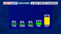
Staying dry for most of the week, late shower possible Friday, better chance for rain Saturday as a strong cold front pushes through the region.
Another cold front moves through Wednesday, bringing a brief increase in west to northwest winds. Temperatures will reach the mid 50s before cooling Wednesday night, with lows falling into the upper 20s to low 30s.
Dry and quieter weather returns Thursday as high pressure briefly builds in, allowing for more sunshine and continued above-average temperatures.
The pattern turns more active late in the week and into the weekend. A warm front is expected to bring scattered showers Friday, along with gusty southerly winds and highs in the low to mid 60s. Another strong cold front will cross Delmarva later Saturday, producing additional showers and even a rumble of thunder Saturday night, followed by sharply colder and blustery conditions. Temperatures will trend closer to seasonal norms by Sunday.