


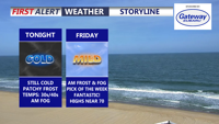
A milder night in Sussex County will reduce the frost threat, but patchy fog and low clouds could develop before a mainly dry Friday.
From
To


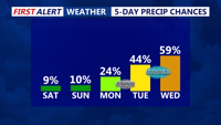
Today starts a much calmer pattern across Delmarva after several days of wild weather that included temperature swings, record highs, and accumulating snow. Skies will be mostly sunny with highs in the upper 40s to low 50s, though gusty south winds will ramp up this afternoon and evening to 35 to 40 mph. The weekend looks pleasant, with sunshine Saturday, more clouds Sunday, and temperatures warming into the upper 50s, 60s, and eventually near 70 by Monday ahead of a powerful cold front. That front could bring strong to severe thunderstorms Monday afternoon and evening, along with heavy rain and damaging wind gusts, before much colder air rushes back in for Tuesday and Wednesday.


Delmarva stays locked under clouds today as a backdoor cold front keeps temperatures chilly, especially near the beaches. Fog and drizzle develop tonight, then milder air builds in this weekend with partial clearing Saturday afternoon, a chance for showers overnight Saturday into Sunday, and much warmer temperatures arriving early next week.

Sussex County will ride a mild stretch from late Friday through late Saturday evening, then brace for a colder pattern as an arctic front approaches late Saturday night into Sunday.

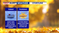
Gusty but seasonable weather holds through the end of the week on Delmarva, with clear skies for possible Northern Lights viewing tonight, rain and a brief warm-up Sunday, and a cooler, windy return early next week.


High pressure gives way to an approaching cold front tonight, bringing a fall-like airmass into Delmarva. While rain isn’t expected, breezy coastal winds and cooler-than-average temperatures will mark the midweek forecast before a warm-up this weekend.


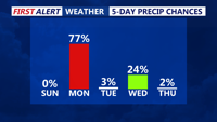
Delmarva will see a mostly dry but cloudy Sunday as low pressure exits the region. Temperatures will rise into the upper 50s and low 60s, with a chance for some afternoon sun. Warmer conditions return Monday ahead of an evening cold front that brings showers and possible storms. A second front on Tuesday ushers in cooler, breezy weather midweek, with frost potential before a warm-up by the weekend.

Delmarva will experience a series of weather changes this week beginning Saturday night, as a cold front ushers in chilly overnight lows. High pressure brings brief clearing Sunday, followed by multiple low-pressure systems bringing rounds of rain through midweek. A gradual warm-up returns by the weekend.


Sussex County, Delaware, and Ocean City, Maryland, will experience gusty winds and below-normal temperatures late Thursday into Friday, with calmer conditions and a gradual warming trend through the weekend.


High pressure will bring clear skies, cool temperatures, and breezy conditions to Delmarva through Friday, with warmer temperatures expected by Saturday as a weak cold front passes through.