


Cloudy, cooler conditions will continue across Sussex County through Thursday before quieter weather returns Thursday night.
From
To


A quieter and less humid stretch begins today following Tuesday evening’s severe storms across Delmarva.

Sunshine, low humidity and comfortable temperatures will make Monday one of the nicest July days on Delmarva before heat and humidity build through midweek.


A quieter, sunnier Wednesday will give way to rounds of storms, heavy rain and a renewed flash flooding risk Thursday and Friday.


A few showers may linger early Friday in Sussex County before cooler, less humid weather takes hold into early Saturday.

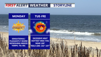
Delmarva will face another day of near-record heat, high humidity, and a slight risk for severe thunderstorms today. A cold front moving through tonight will bring a more comfortable weekend, though another round of showers and storms could return late Sunday into Sunday night.

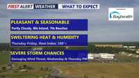
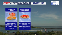
Delmarva will enjoy a beautiful and seasonable day today, with highs in the low 80s inland and low 70s along the coast. Humidity begins to return tonight, setting the stage for scattered showers and storms Wednesday and Thursday. Dangerous heat is likely late this week, especially Thursday and Friday, before a cold front brings some relief into the weekend.


Sussex County will see a warm, mostly dry Saturday before scattered showers and thunderstorms move in Saturday night into early Sunday.

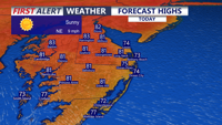
Delmarva will enjoy sunny, dry weather today through the end of the week as high pressure remains in control. Inland temperatures will climb from the upper 70s and low 80s today into the low 90s by Friday and Saturday, while beaches stay cooler thanks to sea breezes. A cooler, unsettled pattern arrives late this weekend into early next week with showers and thunderstorms possible.


Fog and low clouds may linger late Saturday night before Sussex County sees a warmer, mainly dry Sunday, with rain chances increasing again late Sunday evening.