


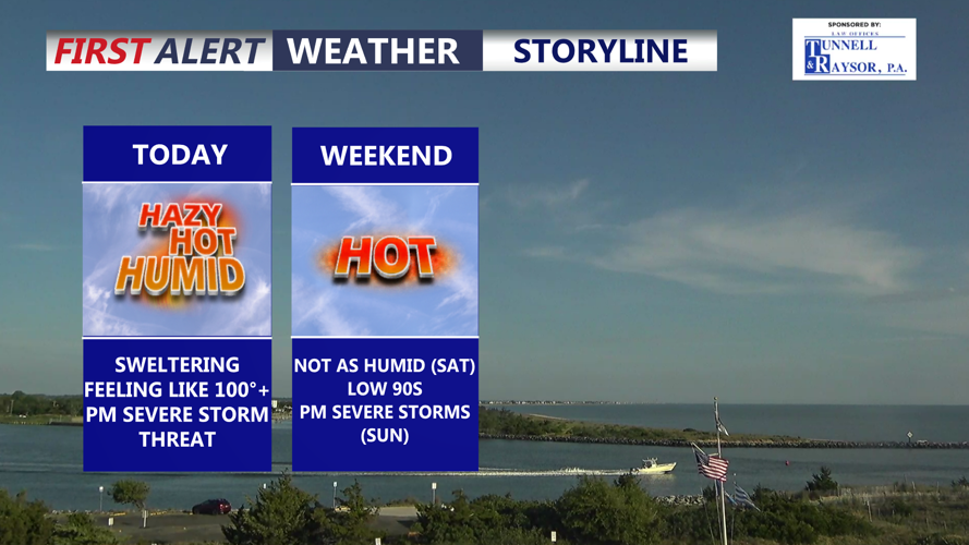


DELMARVA -- One more day of dangerous heat and humidity today before more comfortable air arrives for the weekend.
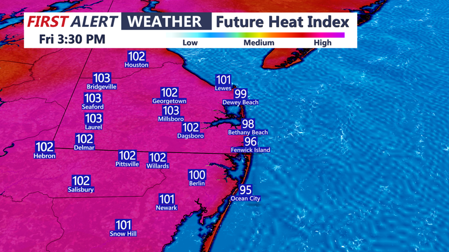
High pressure offshore will continue to pump a hot and humid air mass into the peninsula, while a mid-level ridge begins to slide away from the Mid-Atlantic. Temperatures are expected to climb into the low to mid 90s across much of Delmarva, with heat index values peaking between 95 and 105 degrees.

Feeling like 100 to 104 this afternoon as stifling heat and humidity continue.
Near-record heat is possible again today. In Georgetown, the record high is 95 degrees, set in 2017, and that mark could be challenged. Highs in the mid to upper 90s.
Humidity will remain high early in the day, with dewpoints starting in the low to mid 70s. Some afternoon mixing may help bring dewpoints down slightly into the upper 60s and low 70s, but conditions will still feel hot and uncomfortable through much of the day.
Showers and thunderstorms are expected to develop late this afternoon and evening as a cold front approaches from the west. Delmarva is under a slight risk, level 2 out of 5, for severe thunderstorms today. Damaging wind gusts will be the main concern with any stronger storms that develop. The risk for tornadoes and large hail remains low.

SLIGHT risk 2 of 5 for severe storms between 6PM-11PM, damaging winds in the primary threat.
Storm coverage remains somewhat uncertain, as subtle sinking air aloft could limit development for part of the afternoon. However, where storms do form, the environment may still support strong to severe activity.
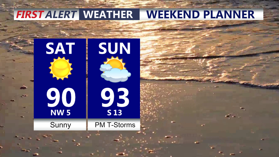
A cold front will move through Delmarva tonight, bringing lower temperatures and a noticeable drop in humidity. The weekend will still be warm, with highs generally in the upper 80s to low 90s, but dewpoints will fall to much more comfortable levels. Some areas may see dewpoints drop into the 50s on Saturday, making the heat index much less of a factor. Highs Sunday will be in the low 90s under mostly sunny skies.

Sunny hot Saturday, not as humid, another severe storm threat late Sunday afternoon-evening.
Another cold front will approach late Sunday into Sunday night, bringing renewed chances for scattered showers and thunderstorms. There is another slight risk, level 2 out of 5, for severe storms during that period. The severe weather threat will depend on how much moisture and instability can return before the front arrives. A slower front would allow a greater storm threat, while a faster front would likely limit the risk.
Behind that front, a more seasonable air mass will settle over Delmarva through at least the middle of next week. Highs Monday through Wednesday are expected to range from the mid 70s to mid 80s, with overnight lows in the mid 50s to low 60s. Lower humidity will make conditions feel much more pleasant, and rain chances look generally low during that stretch.
