


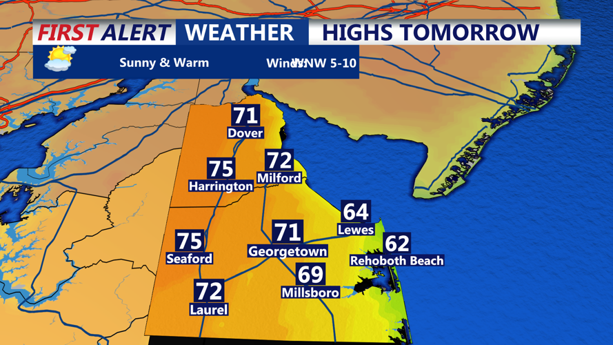


DELMARVA - Late Tuesday evening will usher in a noticeable shift in the weather pattern for Delaware’s beach communities. While inland portions of Sussex County and much of Delmarva climbed into the low 80s during the day, places like Rehoboth Beach, Dewey Beach, Bethany Beach and Fenwick Island stayed much cooler, thanks to a breeze off the ocean. Highs along the shoreline peaked in the upper 60s to low 70s under a mix of sunshine and scattered clouds.
Overnight, a northeast flow will strengthen across the region, pulling in cooler and drier air. This will lead to a noticeable dip in temperatures across the coast. By early Wednesday morning, beach communities can expect lows in the upper 40s to low 50s, which may call for an extra layer if you're heading out early.
Wednesday will offer a calm and pleasant fall-like day with a blend of sun and clouds. Highs across the coastal strip will settle in the low to mid 70s—comfortable and dry for any outdoor activities. Similar conditions are expected to hold through Friday, making it an ideal stretch for midweek beachgoers or anyone looking to enjoy a walk along the boardwalk.
However, this tranquil stretch won’t last long. We are already keeping a close eye on the weekend, especially Saturday, when rain chances begin to climb. Thunderstorms are also possible as the atmosphere becomes more unsettled. With wet weather on the horizon, residents and visitors alike may want to prepare a “Plan B” in case outdoor plans are impacted.
