


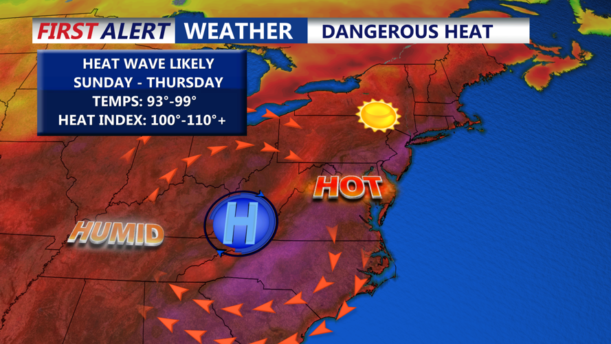


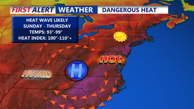
DELMARVA -- The first weekend of summer has arrived on Delmarva, and it’s coming in hot — literally. What begins as a partly sunny and humid Sunday will quickly escalate into a dangerous, multi-day heat wave gripping much of the region through the middle of the week.

Partly sunny highs in the upper 80s to low 90s, a muggy warm evening on Delmarva.
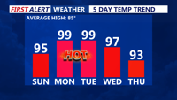
Sunday brings partly sunny skies, with temperatures inland and upper 80s to low 90s along the coast, bit warmer further to the southwest. There was decaying thunderstorms well to our north so we have seen a clouds put a wrinkle in the forecast. Humidity will noticeably increase, pushing heat index values close to 100 degrees in interior sections. Sunday night remains very warm and muggy, with lows only falling into the low 70s as dew points climb.
Beginning Monday, a strong dome of hot and dry high pressure building from the western Atlantic into the Appalachians will usher in near-record temperatures across the eastern U.S., including Delmarva. This upper-level ridge, combined with weak sea breezes and downslope winds from the west-northwest, will make for one of the most favorable heat setups in recent memory.

Oppressive heat and humidity with highs approaching near record highs Monday and Tuesday.
A Heat Advisory is in effect from 8 a.m. Monday to 8 p.m. Tuesday for Sussex and Kent counties in Delaware and Caroline and Talbot counties in Maryland. Forecast highs for Monday and Tuesday are expected to approach 100 degrees, with heat indices ranging from 105 to 110 degrees — conditions that can quickly become dangerous for anyone outdoors for extended periods.
Overnight relief will be minimal, with lows only dropping into the upper 70s — and potentially near 80 degrees in urban areas. These warm nights compound the stress on the human body, especially during prolonged heat events.
Looking ahead to Wednesday and Thursday, the ridge is expected to weaken and flatten, allowing a slow trend toward slightly cooler conditions. Highs will still reach the mid to upper 90s on Wednesday, making it the fourth straight day of 95+ temperatures. Some increase in clouds and a slight chance for showers or thunderstorms may arrive late Wednesday, but confidence remains low due to uncertainty about the position of an approaching cold front.
By Friday, the ridge may erode further, bringing highs back into the 80s and raising the likelihood for scattered storms as a trough digs in from the north.

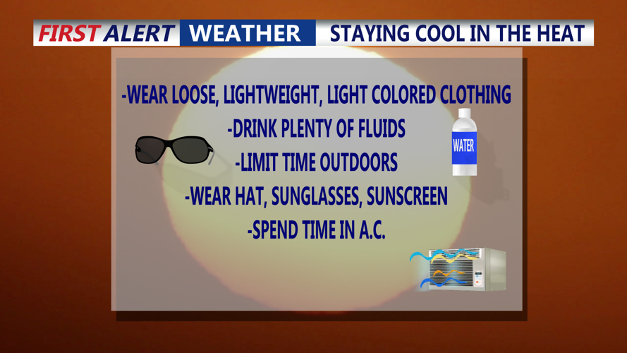
Tips for staying safe during the heat wave.
Safety Reminders:
Stay hydrated and avoid strenuous activity during the hottest parts of the day.
Seek shade or air-conditioned spaces whenever possible.
Never leave children or pets in vehicles.
Check on elderly neighbors and those without access to cooling.
