


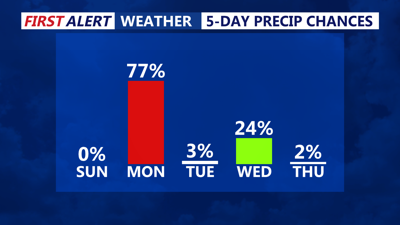
DELMARVA -- A stretch of unsettled weather is set to begin across the region starting Sunday night as multiple systems move through Delmarva, bringing periods of rain and a chance of wintry precipitation by midweek.
Clouds increase Sunday night as high pressure slides offshore and a warm front lifts into the region. Scattered showers are expected to move in from west to east overnight. Temperatures will briefly drop into the low 30s to low 40s early in the night before rising slightly toward daybreak Monday as warm air pushes northward.
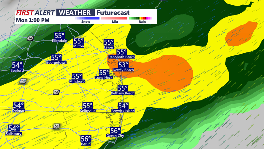
Monday will feel milder, with highs reaching the low 60s across Delmarva. Winds shift from the south in the morning to a more westerly direction during the afternoon following the passage of a cold front. A brief period of moderate rain is likely around midday into the afternoon hours.

Brief hitting rain Monday afternoon, could be heavy at times.
Tuesday brings a brief break in precipitation, but cooler air follows behind the front, with highs only reaching the mid-50s.
Another round of unsettled weather arrives late Tuesday night into Wednesday as an upper-level trough settles over the region. A low pressure system from the west could bring precipitation starting late Tuesday night. Showers are expected to taper off by early Wednesday afternoon.
Conditions are forecast to improve late in the week. High pressure and upper-level ridging return, bringing dry weather and gradually warming temperatures Thursday into Saturday back into the 60s to eventually 70s by next weekend.
