


A stretch of dry weather will give way to unsettled conditions beginning Tuesday night as a coastal low pressure system develops offshore and brings showers, breezy winds and cooler temperatures to Sussex County.
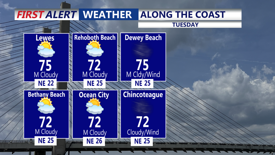
Tuesday will begin mostly dry, with highs in the low to mid-70s under partly sunny skies. An east-northeast wind near 10 mph will occasionally gust between 15 and 20 mph, and clouds will thicken through the afternoon as the offshore system organizes. While most of the county will remain rain-free during the day, forecasters say a stray shower could develop along the beaches by late afternoon.
By Tuesday night, the low will track northward just offshore, sending scattered showers into coastal Delaware. Isolated thunderstorms are possible along the coast, while inland communities may see lighter precipitation. Winds will strengthen overnight, with gusts up to 30 mph possible along the shoreline.
On Wednesday, unsettled conditions are expected to continue. Showers will remain scattered, and an isolated thunderstorm cannot be ruled out in Sussex County. High temperatures will be held to the upper 60s and low 70s by persistent northeast winds, which will gust near 20 mph inland and closer to 30 mph near the beaches.
Conditions are forecast to improve late Wednesday into Thursday morning as the coastal system moves out to sea. Clouds will decrease through the day Thursday, bringing more sunshine and a return to milder weather. Highs will rebound into the mid- to upper 70s with lighter winds.