


DELMARVA - A significant shift in weather is on the way for Sussex County, with a slow-moving cold front expected to bring widespread showers and thunderstorms beginning late Wednesday evening and continuing through Thursday night.
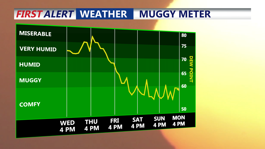
Forecasters say hot and humid conditions will persist into Wednesday evening before the cold front approaches from the west. Scattered storms could develop during this period, carrying the potential for locally heavy rain and gusty winds. By Thursday afternoon, abundant moisture from the front is expected to produce periods of heavy rainfall, which could lead to localized flash flooding. Rainfall amounts of two to four inches are likely, with some areas potentially seeing higher totals.
The heaviest showers and storms are expected to taper off late Thursday night into early Friday. In the wake of the front, high pressure will build in from the north, ushering in cooler, drier air. Friday will feel noticeably different, with high temperatures mostly in the 70s and gusty northeast winds up to 30 mph along the coast. Lingering showers and drizzle may persist into Friday morning, but conditions will gradually improve through the day.
By Friday night, drier air will settle into the region, dropping temperatures into the 50s and 60s overnight and bringing a stretch of pleasant, below-normal temperatures into the weekend. Dew points are expected to drop into the 50s, making for more comfortable conditions heading into early next week.
The next chance for widespread rain is forecast to arrive around Tuesday or Wednesday of next week as another system approaches the Mid-Atlantic.
