


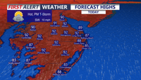


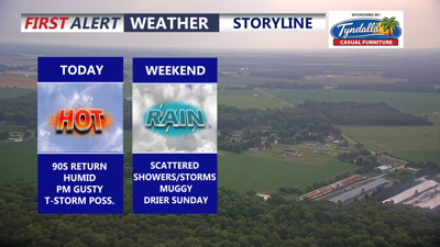
DELMARVA -- Hot and humid conditions will continue across Delmarva today, with partly sunny skies and highs reaching the upper 80s to low 90s inland. Some beach communities could climb into the mid-90s before unsettled weather arrives later in the day. Southwest winds will remain light to moderate, generally 5 to 15 mph.

Back into the low 90s, 80s at the beaches, isolated gusty t-storm possible this evening.
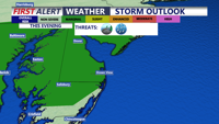
The Storm Prediction Center has placed much of the area under a Marginal Risk for severe storms this evening through tonight. While widespread severe weather is not expected, a few stronger storms could produce damaging wind gusts as a cold front approaches and slowly moves through the region.

Marginal severe storm risk this evening-tonight, damaging winds being the primary threat.
Scattered showers and a rumble of thunder are expected tonight, with temperatures falling to around 70 degrees. The front will drift southeast across Delmarva as low pressure over the Ohio Valley slowly moves east, allowing showers to increase again late tonight and into Saturday.
Saturday will remain muggy and unsettled, with on-and-off showers and storms possible throughout the day. Highs will be cooler, topping out near 81 degrees, but humidity will remain noticeable.
Conditions improve by Sunday as the front sags farther south into the Mid-Atlantic and high pressure builds in from the north. Sunday will be the drier day of the weekend, with partly cloudy skies and highs in the low to mid-80s.

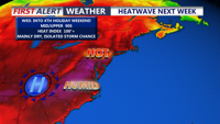
Hot stretch develops next week through the 4th of July holiday weekend, heat indices could exceed 105 degrees.
Looking ahead, heat is expected to build back into Delmarva by the middle and end of next week. Highs may climb well into the 90s beginning as early as Wednesday and continuing through Friday, with heat index values near or above 100 degrees, especially Thursday and Friday afternoons.
