


DELMARVA - A sharp cold front is sweeping across coastal Delaware Tuesday evening, ushering in strong gusty winds and a notable drop in temperatures across the region. From Prime Hook to Lewes, through Rehoboth Beach and all the way down to Fenwick Island, beach communities can expect a noticeable shift in conditions through Wednesday.
As the front pushes through Tuesday evening, a strong upper-level disturbance will create lift in the atmosphere, triggering isolated to scattered showers. While the overall storm threat remains minimal, brief thunderstorms may develop, with a small chance for damaging wind gusts and even some small hail—mainly farther north in the region.
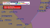
The bigger story for the beach towns will be the winds. A Wind Advisory is in effect through 8 p.m. Tuesday, with gusts over 45 mph already being recorded inland and expected to impact coastal areas as well. Winds will remain elevated overnight, with gusts in the 20-30 mph range making it feel much colder, especially along the coastline.
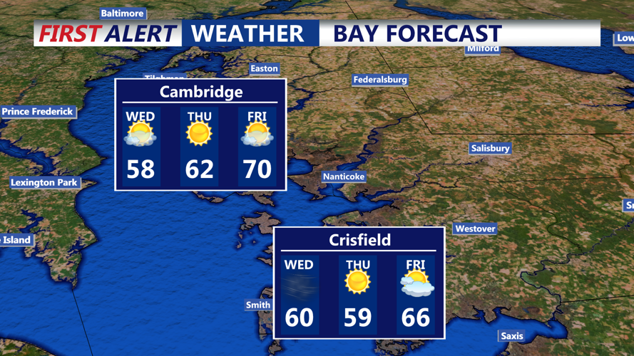
By Wednesday, skies will gradually clear and temperatures will remain cool. While winds won’t be as fierce as Tuesday, gusts could still top 30-35 mph during the day, keeping conditions brisk for anyone planning a beach walk or outdoor activity.
Wednesday night into Thursday morning brings the possibility of frost, especially inland and away from the water. Overnight temperatures could dip near freezing in protected areas, though coastal towns may stay a few degrees warmer thanks to the moderating influence of the ocean.
Sunshine returns Thursday, making for the sunniest day of the week. Highs will rebound slightly, reaching the low 60s, with calmer winds expected. By Friday, clouds roll back in ahead of another warm front, but the beaches should stay dry, with highs climbing into the upper 60s to near 70.
The weekend looks warmer but unsettled, with a chance of rain and thunderstorms by Saturday evening. However, the forecast beyond Saturday remains uncertain, with differing models suggesting either dry and cooler weather or lingering warmth and unsettled skies.
Residents and visitors alike are advised to bundle up and secure any loose outdoor items as the wind event continues Tuesday night. Stay tuned to local updates for the latest weather conditions across Sussex County’s beach communities.
