


DELMARVA - The start of the workweek will bring cool, calm conditions to Sussex County before a shift toward breezier and cloudier weather late Monday into early Tuesday, forecasters said.
High pressure anchored over the Great Lakes and eastern Canada will continue to dominate the region through Monday morning, maintaining partly sunny skies and light northeast winds around 5 to 10 mph. Daytime highs are expected to reach the upper 50s to near 60 degrees.
As Monday evening approaches, a developing area of low pressure off the Carolina coast will begin to move eastward. While the system is forecast to stay offshore, it will enhance onshore flow across coastal Delaware. Winds will strengthen overnight, especially near the beaches, where gusts could reach 30 to 35 mph by early Tuesday. Inland areas should see sustained winds near 10 to 15 mph with gusts up to 20 mph.
Cloud cover will increase Monday night, and there is a small chance of drizzle or light showers along the immediate coast into Tuesday morning. Overnight lows will remain cool, in the upper 30s inland to low 40s near the shore, with slightly milder readings due to cloud insulation.
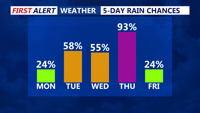
By early Tuesday, conditions are expected to stay mostly dry but breezy, with cooler-than-average temperatures continuing under a persistent northeast flow. The National Weather Service notes that this setup marks the beginning of a more unsettled pattern later in the week, with stronger systems and rain chances developing by midweek.