


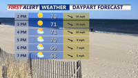


DELMARVA -- Sunday afternoon on Delmarva will offer a welcome stretch of fair weather with fewer clouds than Saturday. Light west to northwest winds will generally hover around 10 mph, with a few gusts up to 20 mph possible. Temperatures will remain cooler than average for late May, reaching only the upper 60s to low 70s across the region.

Highs in the lower 70s, increasing clouds through the evening as a passing shower is possible overnight.
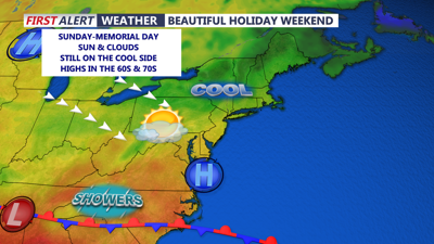
The calmer weather is driven by a high-pressure system building in from the north and west, as low pressure exits the region toward the Canadian Maritimes. This high will continue to influence the region into Sunday night and through Memorial Day, helping to maintain generally dry and tranquil conditions.

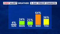
Rain chances ramp up Wednesday as an area of low pressure will bring periods of rain.
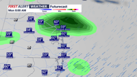
However, a weak disturbance will track south of Delmarva Sunday night, and while most forecast guidance keeps the associated precipitation to the south, there remains a 20 to 30 percent chance of scattered showers for the area overnight.

A brief shower is possible overnight Sunday into early Monday.
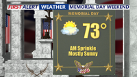
Memorial Day looks to be a mild and enjoyable holiday. With partly to mostly sunny skies and light winds, high temperatures are expected to climb into the low to mid 70s inland, with slightly cooler readings along the coast due to developing sea breezes.

After some morning clouds look for a mostly sunny pleasant afternoon with highs in the low to mid 70s.
By Monday night, high pressure will crest over the region before beginning to pull away to the east on Tuesday. The weather will stay dry Tuesday, but increasing mid and high level clouds will be noticeable as the next system approaches from the Midwest. Lows Monday night will range from the mid 40s to mid 50s, while highs Tuesday will be similar to Monday, remaining in the low to mid 70s except along the cooler coastal areas.
Rain chances return to the forecast Tuesday night into Wednesday as a low-pressure system advances from the Midwest. While models differ on how organized the system will be, at least some rainfall appears likely. The GFS model suggests a weaker and shorter-lived event with clearing by Wednesday afternoon, while other models such as the ECMWF and GEM depict a more prolonged unsettled period through Wednesday.
Later in the week, another cold front may bring additional showers and possible thunderstorms Thursday into Friday. As a new upper-level low moves into the region late in the week, lingering chances for scattered showers and storms may persist into next weekend, particularly during the afternoon hours. While it will not be a washout, several days of intermittent wet weather appear likely as the pattern turns more unsettled.