


DELMARVA -- After a picture-perfect Mother's Day featuring highs in the low 80s and mostly sunny skies, the Delmarva Peninsula is in for a shift in weather this week as multiple systems move into the region.

On & off showers develop Tuesday, with the heaviest late Tuesday night into Wednesday morning.
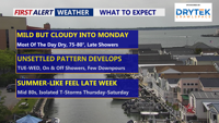
Sunday night will stay dry with mostly cloudy skies and overnight lows dipping into the mid-50s. Winds will shift gradually from northeasterly to southerly by Monday afternoon, staying light at 5 to 10 mph. High clouds are expected to increase across the region overnight and into Monday, allowing for partial sun in the morning before thickening clouds take over by late day. Highs inland will be 75 to 80, 72 to 76 at the coast.

Highs near 80 under mostly cloudy skies and a chance for a late shower.
High pressure currently dominating the region will slowly drift eastward by Monday night. Meanwhile, an area of low pressure, currently over the lower Mississippi Valley and western Gulf Coast, is expected to lift northeastward—bringing with it widespread showers by Tuesday.
Scattered showers will begin late Monday, mainly affecting the Maryland Eastern Shore and southern Delaware. By Tuesday, rain will spread northeastward across the entire region and continue through Wednesday.

Widespread rain and even a rumble of thunder late Tuesday into early Wednesday morning.
While most rainfall will remain light, periods of moderate to heavy showers are possible, especially across Delmarva especially late Tuesday. Rain totals between a half inch and an inch are expected through Wednesday, with locally higher amounts possible. Isolated thunderstorms may also develop Tuesday night, though no severe weather is currently anticipated.

Between Tuesday and Wednesday we could see up to an 1" of rain on Delmarva.
Daytime temperatures will cool into the upper 60s to low 70s on Tuesday and Wednesday due to persistent cloud cover and rain. Nighttime lows will remain mild, hovering in the 50s to low 60s.
As the low-pressure system transitions into a shortwave trough, showers will linger into Wednesday night and Thursday. Although rainfall may ease up Thursday morning, scattered showers are expected to return by the afternoon. Highs will rebound into the 70s, with overnight temperatures staying in the low to mid-60s.
A brief window of drier conditions is forecast from Thursday night into early Friday, thanks to a temporary ridge of high pressure. However, this lull will be short-lived. Another low-pressure system from the Great Lakes is expected to push additional cold fronts through the area late Friday and again on Saturday.
Both days will feature highs climbing into the 80s, with an uptick in humidity, along with increased instability that could support thunderstorms. While it’s too early to pinpoint severe weather potential, the threat for thunderstorms will exist.
