


DELMARVA - A gloomy start to the week continues across Delmarva as low pressure tracks along a stationary front draped over the Mid-Atlantic. Monday will bring more of the same: cloudy skies, occasional mist or drizzle, and scattered showers. While the timing and location of rainfall will be hit-or-miss, there is a 20 percent to 30 percent chance of rain throughout the day, with slightly higher chances overnight. Despite periods of heavier rain, the risk for flooding remains low as any downpours will be brief.

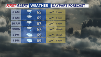
Showers and drizzle to start our Monday, still cool with highs around 70.
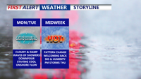
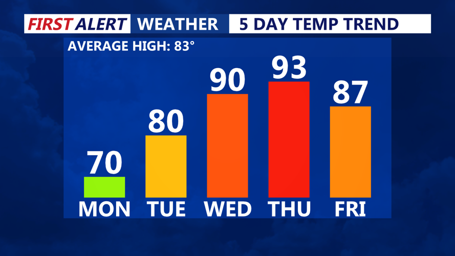
Temperatures Monday will feel more like spring than summer, with highs in the upper 60s to low/mid 70s. Monday night, lows will settle in the mid-60s as another weak low approaches from the west. This will begin to lift the stationary boundary north as a warm front, but the full transition isn’t expected until Tuesday night.
Tuesday will bring gradual warming, with highs reaching the upper 70s to near 80 under cloudy skies. Showers are likely again late Monday night into Tuesday morning and then again Tuesday night into Wednesday morning as the region sits in a transition zone between air masses.

90s will make a return on Delmarva Wednesday and Thursday, as will the humidity.
By Wednesday, the warm front will be north of the area, ushering in a surge of warm and humid air from the south. High temperatures are forecast to climb into the mid to upper 80s across Delmarva. Several upper-level disturbances will bring the potential for scattered showers and thunderstorms throughout the day.
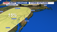
Thursday will mark the peak of the heat and humidity as a Bermuda high anchors offshore. Highs are expected to push into the low 90s, with dew points in the low 70s creating heat index values in the upper 90s. Heat Advisories may be needed depending on how oppressive conditions become. A strong cold front is expected to move through late Thursday, bringing the threat of afternoon and evening thunderstorms. Some storms could be severe, with the Storm Prediction Center placing parts of the Mid-Atlantic under a 15 percent risk for severe weather.

Storm Prediction Center has a 15% chance for severe storms Thursday afternoon/night just to our west. Will keep a close eye on the evolution of this threat in the days ahead.
Cooler and more comfortable air moves in by Friday as high pressure builds from the north and west. While a passing upper trough could spark a few showers in northern areas, much of Delmarva should remain dry with highs in the low to mid-80s and lower humidity. Sunny and pleasant weather is expected to continue into Saturday, with another potential cold front arriving Sunday.
As we look into the extend forecast, we could see our first heatwave of the year potentially between June 23 - 29 as a big ridge build across the eastern U.S.