


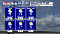


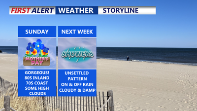
DELMARVA -- Mother’s Day across the Delmarva Peninsula will be a warm and dry one, as high pressure builds from the northwest and ushers in seasonably pleasant weather. Temperatures are expected to reach the upper 70s to low 80s inland, while coastal areas should see highs in the mid to upper 70s under filtered sunshine.

Temperatures will be a good 10 degrees warmer than yesterday.

Partly cloudy Mother's Day along the coast with highs in the mid to upper 70s.
An upper-level ridge will begin developing Sunday, helping to keep the region dry despite some cirrus clouds drifting in, especially across southern Delmarva. Sunday night will remain quiet, though more high-level clouds will spread in from the southwest as a low-pressure system begins to stir over the western Gulf Coast. Lows will fall into the 50s.
The early part of the workweek will bring a noticeable shift. While Monday is expected to remain dry with highs in the 70s to near 80 degrees, cloud cover will gradually increase through the day. By Monday night, the chance for scattered showers grows as the Gulf low lifts northeast.

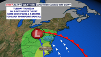
Another pesky closed off low could bring on and off showers Tuesday-Thursday.
Tuesday will feature more widespread rain across Delmarva, especially in the morning and afternoon hours. However, we are not expecting a total washout—intermittent dry periods are likely. Rainfall totals through Tuesday may reach around a half inch on Delmarva. Highs Tuesday should hold near 70 degrees as cloud cover dominates. Instability is expected to remain low due to an onshore southeasterly flow, meaning thunderstorms are not likely at this time.
The unsettled pattern continues Tuesday night into Wednesday as the low transitions into a broad trough that swings through the region. Showers remain likely Wednesday, with the slight potential for a few rumbles of thunder, though any severe weather threat appears minimal. Highs will hover near 70 degrees, with cooler temperatures near the coast and milder readings across central Delmarva.
By Thursday, shower chances begin to taper as the trough exits and sunshine returns. Temperatures will rebound into the mid to upper 70s, with a few inland spots possibly touching 80 degrees. Overnight lows remain mild in the 60s.
Looking ahead to Friday and Saturday, another closed low forming over the Great Lakes could bring additional rounds of showers and possibly some afternoon thunderstorms. The best chance for activity will be north and inland, where instability may be slightly higher. Highs both days are expected to reach the low to mid-80s, adding to the potential for thunderstorm development, especially if a weak cold front crosses the area.