







DELMARVA - A stretch of dry, seasonable weather will continue across Sussex County through the middle of the week before a strengthening coastal storm brings the potential for widespread rain, strong winds and possible tidal flooding Thursday into Friday night.
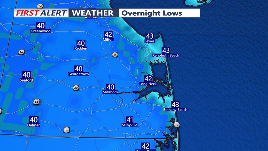
Following Monday's blustery conditions, winds will gradually diminish during the evening as high pressure approaches southern Delaware from the southwest. Skies will remain partly clear overnight, with temperatures falling into the middle to upper 30s across inland communities, including Georgetown, Seaford, Laurel and Bridgeville.
Coastal locations, including Lewes, Rehoboth Beach, Bethany Beach and Fenwick Island, should remain slightly milder, with overnight temperatures generally in the lower to middle 40s.
Some patchy frost could develop across sheltered inland locations early Tuesday morning, although confidence remains low. Increasing midlevel cloud cover after midnight may prevent temperatures near the ground from falling enough for widespread frost formation.
No Frost Advisories have been issued.
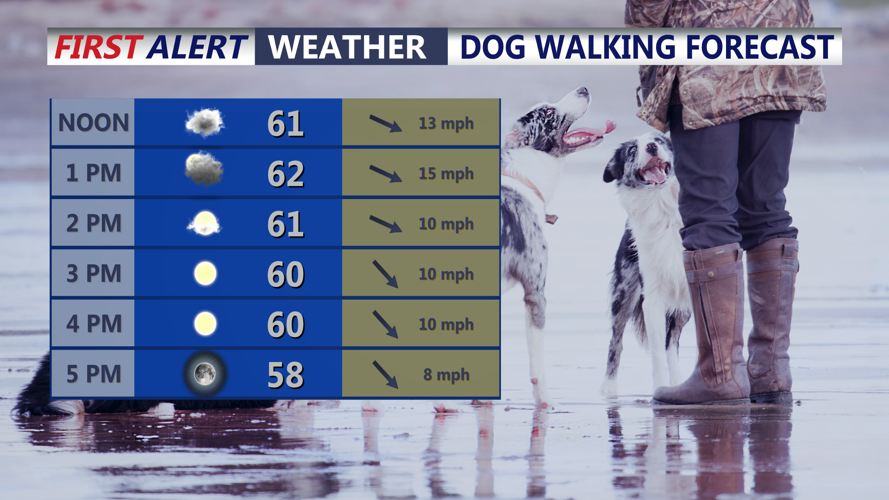
Tuesday will feature mostly sunny skies and seasonable temperatures, with afternoon highs reaching the lower to middle 60s across Sussex County. Southwest winds will occasionally gust to 20 to 25 mph, but conditions will be considerably less blustery than Monday.
Wednesday should bring another generally dry day, with a mixture of sunshine and clouds and afternoon temperatures again climbing into the lower to middle 60s.
However, significant changes are expected later in the week as a powerful upper-level disturbance develops across the eastern United States.
A strengthening low-pressure system is expected to approach the Mid-Atlantic region Thursday before potentially developing into a coastal storm or nor'easter.
Although the exact storm track remains uncertain, confidence is increasing that Sussex County will experience impacts from the system Thursday through Friday night.
Rain will be the primary precipitation concern across southern Delaware, with periods of moderate to potentially heavy rainfall possible.
Communities including Georgetown, Seaford, Millsboro and Laurel could experience prolonged periods of rain, while coastal locations from Lewes south through Rehoboth Beach, Dewey Beach, Bethany Beach and Fenwick Island may also face increasing winds and rough marine conditions.
The potential for coastal flooding remains uncertain and will depend heavily on the storm's eventual track.
A storm developing farther offshore could produce a longer period of onshore winds, increasing the possibility of elevated water levels along Delaware Bay, the Atlantic beaches and vulnerable back-bay communities.
However, a storm tracking directly across Sussex County could limit the duration of strong onshore winds, potentially reducing coastal flooding impacts.
There is also a possibility that the strongest winds may develop after the storm begins moving away, as colder air rushes into the region from the northwest.
While a brief thunderstorm cannot be ruled out if the storm tracks farther inland and draws warmer air into southern Delaware, widespread thunderstorms are not currently expected.
Snow is not anticipated to be a significant concern for Sussex County, with rain remaining the most likely precipitation type.
The most dramatic change will likely arrive Friday and continue through the weekend as much colder air spreads across southern Delaware behind the departing storm.
Saturday afternoon temperatures may struggle to climb out of the 40s across much of Sussex County, a substantial drop from the lower and middle 60s expected earlier in the week.
Brisk northwest winds could make conditions feel even colder, especially along the Delaware beaches and other exposed locations.
Overnight temperatures during the weekend could fall into the upper 20s and lower 30s across inland Sussex County, bringing the potential for freezing conditions.
Residents with sensitive outdoor plants and remaining seasonal vegetation should prepare for the possibility of a hard freeze as temperatures continue falling.
Marine conditions will also require attention throughout the week.
Small Craft Advisories for the Atlantic coastal waters off Sussex County have been extended through 9 p.m. Monday because of lingering strong winds and rough seas.
Conditions should improve Tuesday and Wednesday before potentially deteriorating again as the late-week storm approaches.
For Sussex County residents, the next two days will offer a relatively quiet period to prepare for the possibility of a significant change in the weather.
While the exact rainfall amounts, strongest winds and coastal flooding potential remain uncertain, the overall forecast increasingly favors a stormy Thursday and Friday followed by a much colder and windy weekend.
The sharp temperature drop may be the most widespread impact across Sussex County, with Saturday bringing a distinctly wintry feel despite the calendar still being in November.
