


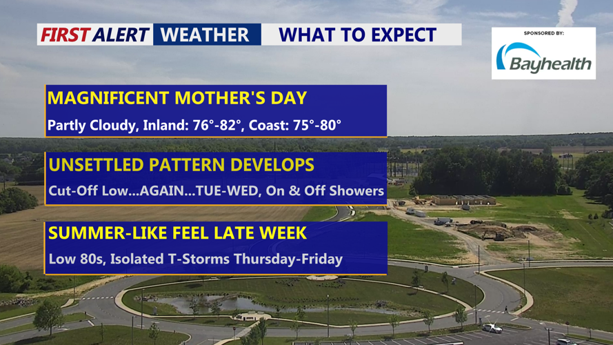


DELMARVA -- A quiet and pleasant weekend continues as a weak cold front passes Saturday night, bringing only scattered high clouds. Behind it, high pressure returns to dominate the weather for Mother’s Day, setting the stage for a warm and gorgeous Sunday.
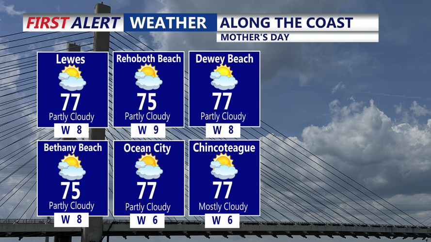
Overnight lows Saturday will settle in the low to mid-50s. Sunday’s forecast calls for sunshine filtered by cirrus clouds, especially across southern Delmarva, as an upper-level ridge strengthens over the region. Daytime highs will climb into the upper 70s to low 80s inland, with mid to upper 70s along the coast.
Happy Mother's Day to all the great moms out there!

Highs Mother's Day in the low 80s inland, mid to upper 70s at the coast.

Partly cloudy Mother's Day with highs in the mid to upper 70s at the coast.
Sunday night remains dry under the influence of the building ridge, though cirrus clouds from a low-pressure system near the Gulf Coast may drift northward. Overnight lows will drop into the 40s in the northern parts of the peninsula and 50s elsewhere.

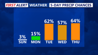
Rain chances increase Tuesday-Thursday as another cut-off low impacts Delmarva.
Changes arrive Monday as the low pressure system moves northeast, increasing cloud cover throughout the day. While showers are not expected during daylight hours Monday, scattered rain becomes more likely Monday night into Tuesday. Temperatures will remain warm, with highs in the 70s to near 80, except cooler along the water.
Rainfall coverage increases by Tuesday, though widespread soaking is not expected. Parts of Delmarva may pick up around a half inch of rain, with some dry periods between showers. The steady cloud cover will help suppress high temperatures to around 70 degrees. A stable onshore flow will also limit thunderstorm development.
Tuesday night into Wednesday, the low pressure weakens into a trough, keeping rain chances elevated. A few isolated thunderstorms are possible, but no severe weather is anticipated. Lows both nights will hold in the 50s north and 60s south, while highs remain near 70 degrees.
Shower chances begin to taper Thursday as the trough lifts, with partly sunny skies allowing temperatures to rebound into the 70s and possibly near 80 in warmer inland locations.
The pattern shifts again bringing a summer-like feel Friday into Saturday as another upper low forms near the Great Lakes. This system may bring additional afternoon showers and thunderstorms, especially for northern parts of the region. Highs both days should reach into the 80s, with some humidity returning and instability increasing for possible thunder.
