


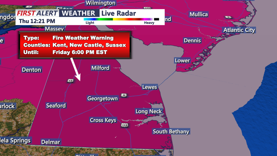


DELMARVA - The Delmarva region will remain under the influence of high pressure as cooler and drier air continues to dominate. While Friday will bring sunny skies and above-average temperatures, fire weather concerns persist due to low humidity and gusty winds. The weather will remain clear and crisp through Friday night into early Saturday, with high pressure keeping conditions calm but cool.
Friday morning will begin with bright sunshine and cool temperatures, with early readings in the upper 30s to low 40s. As the day progresses, high pressure from the Ohio Valley will extend eastward, creating a dry and pleasant day with highs reaching the upper 50s to low 60s in northwestern areas and mid to upper 60s across southeastern portions of the region. Winds from the west will increase slightly to 10–15 mph, with gusts up to 20 mph, contributing to elevated fire weather risks. A Red Flag Warning is in effect for the day, so outdoor burning is strongly discouraged.
By Friday evening, temperatures will cool quickly under clear skies. Breezy northwest to north-northwest winds will persist through the overnight hours, though they will ease slightly, ranging from 5–10 mph. Overnight lows will dip into the mid-30s across northern areas and hover in the low 40s farther south. The air will remain exceptionally dry, with dew points well below normal for this time of year.
Early Saturday morning will continue the trend of clear and dry conditions. A sprawling area of high pressure will dominate, allowing for another cool start to the day. Temperatures in the pre-dawn hours will bottom out in the mid to upper 30s in most areas. The high-pressure system will maintain dry conditions through the day, although fire weather concerns may linger with continued low humidity and dry vegetation.
Looking ahead, temperatures on Saturday will moderate slightly into the mid to upper 50s with lighter winds. The overall pattern will remain tranquil and cool until Sunday, when moisture begins to return ahead of a warm front.