


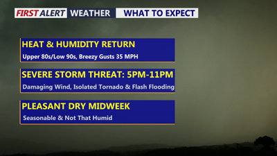
DELMARVA -- A hot, humid and windy day is ahead for Delmarva, with severe thunderstorms possible late this afternoon into tonight.
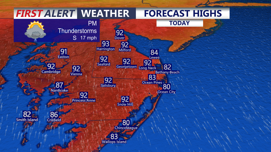
Partly sunny skies will help temperatures climb into the upper 80s to low 90s across much of the peninsula, while beach communities stay a bit cooler in the low to mid 80s. Winds will be gusty at times, and humidity will remain high throughout the day.

Partly sunny, hot, humid and breezy, highs mid 80s at the beaches, low 90s inland with storms late.
Beachgoers should use extra caution. There is a high risk of rip currents today from Ocean City to Chincoteague, while the Delaware beaches are under a moderate rip current risk.
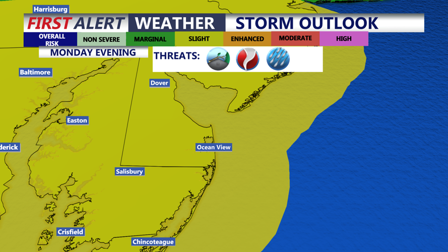
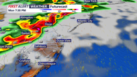
The entire Delmarva Peninsula is under a Slight Risk, level 2 out of 5, for severe weather. Scattered severe storms will be possible, with damaging wind gusts as the main threat. An isolated tornado cannot be ruled out.

Slight risk (2 of 5) for severe storms late this afternoon through the evening, damaging winds & isolated tornado possible.
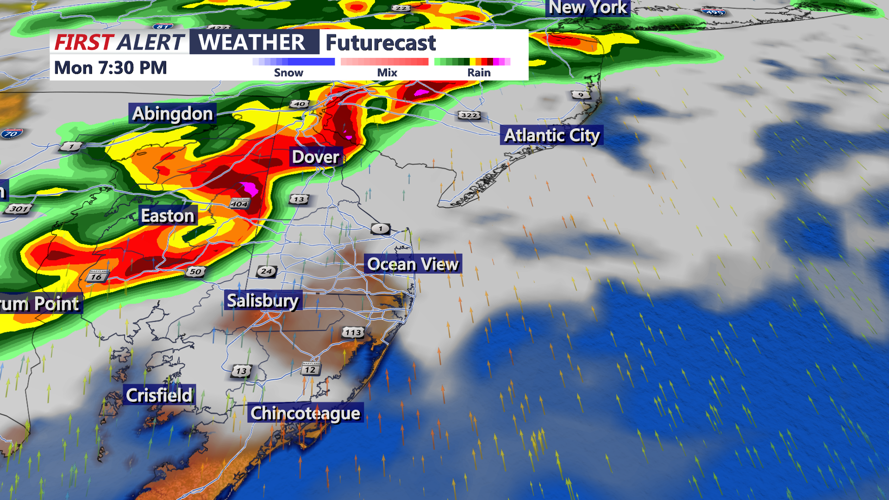
A system moving into the region today and tonight will bring the threat of heavy rainfall, flash flooding and severe storms. Forecast models are coming into better agreement on the track of low pressure, which is expected to move east across southern Pennsylvania this afternoon before crossing the broader region tonight on its way toward southern New England.

Storms will develop late this afternoon into the evening, stay weather aware, storms will likely pack a punch.
This setup is favorable for both severe weather and flash flooding. A very moist atmosphere, strong wind shear and enough instability will allow storms to strengthen as they move across Delmarva. Some storms could produce torrential rainfall, and multiple rounds of storms may lead to areas of flash flooding, especially across northern Delmarva.
The window of greatest concern for Delmarva is roughly 5 p.m. to 11 p.m. Storms may begin as more isolated cells before growing into clusters, with a few embedded stronger storms possible during the late afternoon and evening.
Showers and storms will continue early tonight before conditions gradually become partly cloudy. Overnight lows will fall into the low 70s.
On Tuesday, a secondary cold front may spark a few scattered showers or storms during the afternoon, mainly across southern and eastern portions of the region. These storms are not expected to bring a widespread severe weather or flooding threat. Highs will be in the low to mid 80s.
Quieter, more comfortable weather returns Wednesday and Thursday with mostly sunny skies and highs in the mid 80s.
Another cold front is expected to approach Delmarva late this week, likely Friday into Saturday, bringing another chance for scattered showers and thunderstorms. At this point, the strongest system appears likely to stay well north of the region, but enough moisture and lift may still be present for some late-week storms.
