


DELMARVA -- Improving weather Friday as Hurricane Erin moves northeast and out to sea, but rough surf and dangerous rip currents will linger into the weekend.
As of Thursday afternoon, Erin made its closest pass to the region, remaining about 350 miles southeast of Cape May. The Delmarva coast has been getting battered bat high surf and strong winds, beach erosion and coastal flooding has occurred. Coastal flooding will peak this evening during high tide, that could lead to major coastal flooding up to 3' of inundation. The storm will continue its track northeast, allowing skies to clear overnight. Gusty north to northeast winds will gradually ease, with lows falling between 58 and 65 degrees.
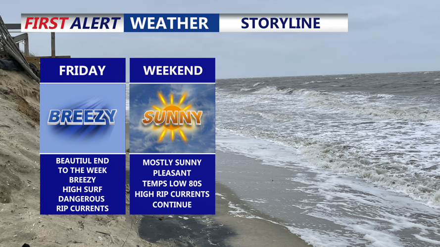
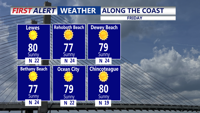
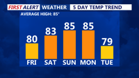
By Friday, high pressure building east from the Great Lakes will bring fair conditions across the region. Sunshine and light north to northwest winds around 10 mph are expected, with highs reaching the low 80s inland and upper 70s farther north.

Wall-to-wall sunshine for Friday, breezy conditions with winds out of the north.
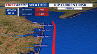
Despite the calmer weather, the ocean remains hazardous, with waves between 5 and 9 feet and long-period swells. A high risk of life-threatening rip currents through at least Saturday and possibly into Sunday.

High surf and a dangerous risk of rip currents continue for Friday and through the weekend.
Heading into the weekend, skies will stay mostly clear Friday night with lows in the upper 50s to lower 60s. Saturday looks sunny and mild, with highs in the low to mid-80s. Humidity will rise Saturday night into Sunday as a cold front approaches from the west. By Sunday afternoon, showers and scattered thunderstorms are expected ahead of the front.

Temperatures will be back up into the 80s under sunny skies, cold front pushes through late Sunday, cooler temperatures middle of next week.
That system will bring widespread rain and storms Sunday night into Monday morning before cooler, drier air settles in Monday night. Another weak front may clip the region Tuesday, followed by a stretch of dry, cool weather through midweek. Highs are forecast in the mid-70s from Tuesday through Thursday, about 10 degrees below average for late August.

