


DELMARVA -- A weakening coastal storm off the Chesapeake Bay is keeping skies cloudy and temperatures below normal across Delmarva Wednesday, but a stretch of drier, sunnier weather is on the way.

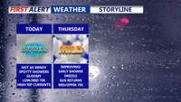
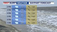
Overcast skies, spotty shower/drizzle, not as windy with highs in the low 70s.
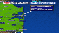
The coastal low, which has been lingering near the mouth of the Chesapeake, will gradually drift northeast and weaken through tonight. Across the Peninsula continued cloudy skies, spotty showers and drizzle, with highs in the low 70s. East-southeast winds of 10 to 20 mph will continue to blow off the ocean, though conditions will be calmer than Tuesday. Coastal Flood Advisories for the Delaware coast until 8PM. Up to a foot and half of inundation possible through high tide cycles.

Coastal Flood Advisory until 8PM, could see up to a foot and half of inundation through high tide.
Lows tonight will dip into the low to mid-60s, with low clouds and patchy fog possible as winds shift to the north at 5 to 10 mph.

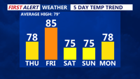
Highs rise back into the 80s with sunny skies on Friday.
By Thursday morning, the system will have weakened into an open trough as it moves farther out to sea. Some lingering showers may occur near the coast early in the day, but skies are expected to clear across the region by afternoon. Highs will climb into the mid to upper 70s along the coast to near 80. Thursday night will bring clear skies and cooler temperatures, with lows in the mid-50s to low 60s.
Friday will mark a return to summer-like conditions ahead of a cold front moving in from the north. Highs are expected to reach the mid to upper 80s across much of Delmarva under mostly sunny skies. Although the front may bring slightly cooler air to areas farther north and west, no rain is expected thanks to dry conditions. Temperatures will fall into the 50s and 60s Friday night as cooler air filters in behind the front.
High pressure from Canada will dominate the weather across the Mid-Atlantic through the weekend and into early next week. Mostly clear skies and light onshore breezes are expected Saturday and Sunday, with cool mornings and comfortable afternoons. Highs in the mid to upper 70s through the weekend.
By Monday and Tuesday, a gradual warming trend will take hold as winds shift southwesterly aloft. Temperatures are forecast to rise back above normal, though only a slight chance of isolated showers near the coast is expected early next week.