


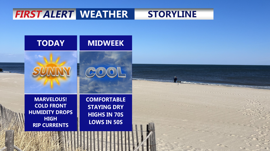

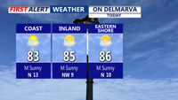


DELMARVA -- A marvelous Monday as summer warmth pairs with refreshing breezes and drier air across the region. Highs will climb into the low to mid-80s today, with a west to northwesterly breeze of 10 to 15 mph and occasional gusts up to 25 mph. Dewpoints, which began in the mid to upper 60s this morning, will fall into the 50s by evening, leaving behind pleasant late-August conditions. HIGH rip current risk continues for the DE Beaches, down to Ocean City to Assateague Island. Waves 3 to 5 ft. Always swim near lifeguards.

Mostly Sunny skies with highs in the low to mid 80s, humidity levels drop through the day.
Tonight, skies remain mostly clear as the breeze eases slightly to 5 to 10 mph. Overnight lows will dip into the upper 50s and lower 60s by Tuesday morning.

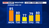
Average high 85, below average temperatures through the week.
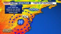
High pressure is expected to dominate through midweek, building from the Mississippi Valley into the Mid-Atlantic. This system will keep the area dry and seasonably cool, with highs in the 70s to near 80 degrees Tuesday and Wednesday. Overnight lows will mostly fall into the 50s, with some inland spots possibly slipping into the 40s by early Wednesday.

Fall-like chill arrives midweek, overnight lows falling into the low to mid 50s, can't even rule out a few low 40s away from the coast.
By Thursday, high pressure shifts offshore, allowing a light southerly flow ahead of a cold front due Friday. While a stray shower is possible late Friday, the system is not expected to bring significant rainfall. Canadian high pressure will quickly return behind the front, setting up a dry and comfortable Labor Day weekend.
Overall, Delmarva can look forward to a stretch of pleasant weather as August ends and September begins, with sunshine, cooler nights, and low humidity making for ideal late-summer conditions.