


DELMARVA - Unsettled summer weather is set to continue across Sussex County from late Monday night through late Tuesday night as tropical moisture remains firmly in place. The remnants of Tropical Storm Chantal will move offshore Monday evening, but their influence will linger, keeping the atmosphere primed for heavy rain and thunderstorms.
Temperatures overnight will stay unusually warm and muggy, with lows only dipping into the low to mid-70s. The combination of high humidity and minimal cooling will make for an uncomfortable night, especially for those without air conditioning.
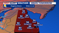
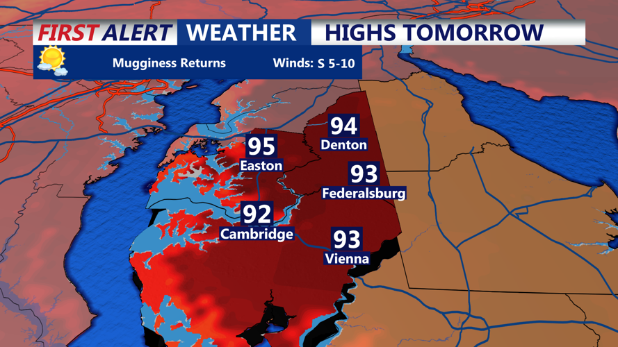
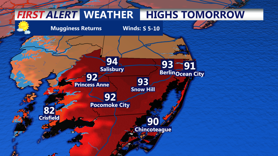
On Tuesday, conditions are expected to become even hotter. High temperatures will reach into the upper 80s to mid-90s across the county. Dewpoints in the low to mid-70s will drive heat index values into the upper 90s, possibly exceeding 100 degrees in some areas. A Heat Advisory may be issued if confidence increases that heat indices will approach or surpass 105 degrees.
In addition to the oppressive heat, multiple rounds of showers and thunderstorms are expected through the day and into the evening. These storms could be slow-moving, tapping into deep tropical moisture. Rainfall rates may exceed 2 inches per hour at times, heightening the risk for flash flooding in low-lying and poor-drainage areas. The National Weather Service has indicated that repeated rounds of heavy rain over multiple days could further aggravate flooding concerns.
Any stronger storms Tuesday may also produce locally damaging wind gusts. The risk of severe weather remains marginal, but forecasters are urging residents to stay weather-aware and monitor updated forecasts.
By late Tuesday night, the front responsible for triggering showers will remain nearby, keeping the air warm and damp. Overnight lows will once again hover in the 70s under mostly cloudy skies, with patchy fog possible in areas that receive significant rainfall.
Residents should prepare for an active stretch of weather, including high heat, dangerous humidity, and the potential for flooding rains. Stay tuned to Coast-TV and local authorities for updates on advisories, warnings, or changes to the forecast.