


DELMARVA -- Starting the week on an unseasonably warm and humid note, with a stretch of summerlike weather more typical of July than late September. A warm front will lift north of the region Tuesday, followed by a cold front pushing in late Wednesday into Wednesday night before stalling south of the area on Thursday.

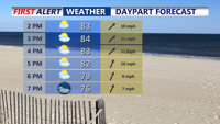
Mostly sunny to partly cloudy skies with highs 77 to 86 this afternoon.
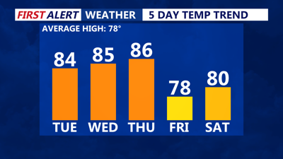
Today features mostly sunny to partly cloudy skies, with temperatures climbing between 77 and 86 degrees and muggy conditions persisting. Showers and a few isolated severe storms may develop west of Delmarva late Tuesday into the evening. An isolated shower or storm cannot be ruled out across the Mid-Shore and Kent County, Delaware as well. Overnight, it will remain partly cloudy and muggy, with lows in the mid-60s.

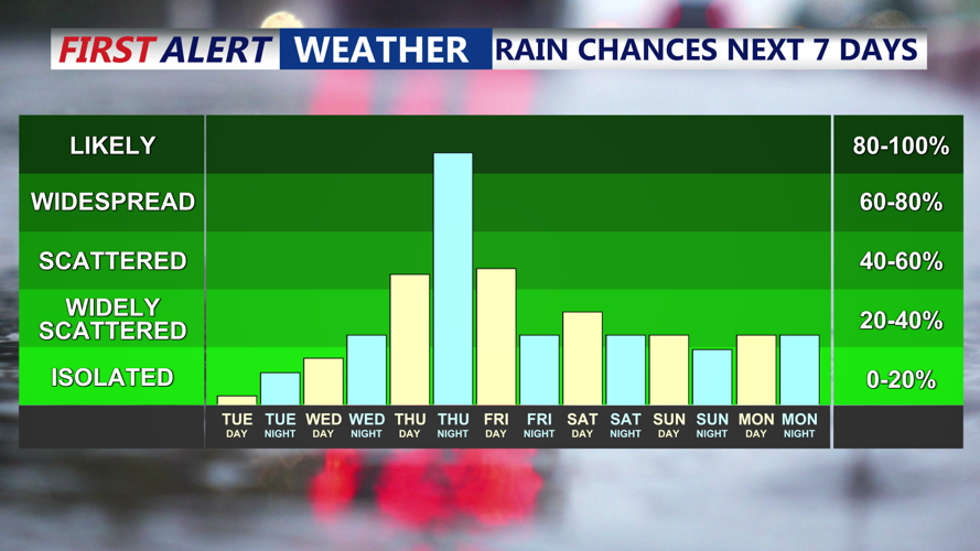
Isolated shower late tonight better chances Wednesday evening, then Thursday late afternoon-Friday.
Wednesday will bring another warm and sticky day with highs in the low to mid-80s and dew points reaching the 70s. Scattered showers and thunderstorms are possible, primarily Wednesday evening into early Thursday morning, as a cold front approaches.
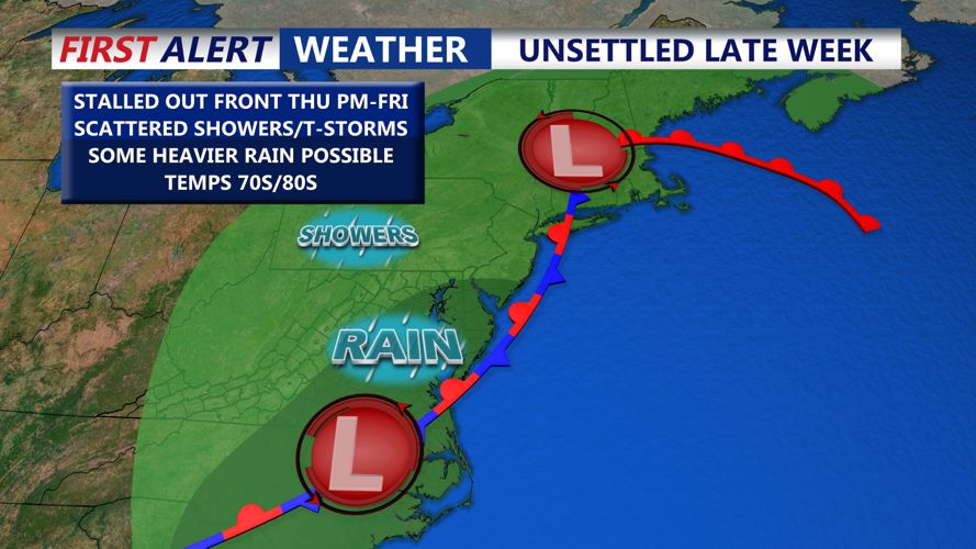
Thursday continues the trend of warm and humid conditions, with highs in the mid- to upper 80s ahead of another cold front that will bring showers and thunderstorms late Thursday afternoon and evening. The Storm Prediction Center has placed the entire Delmarva Peninsula in a marginal risk (1 out of 5) for isolated severe storms Thursday. Damaging winds over 60 mph will be the main threat. The front is expected to stall over the region Thursday night into Friday.

Isolated severe storms possible late Thursday, front stalls out and brings a chance for showers and damp conditions Friday.
Heading into the weekend, the cold front will gradually push through on Friday but linger into Saturday, keeping at least a chance of showers and isolated thunderstorms—particularly across southern Delmarva near the stalled boundary. Broad high pressure will begin building in from the west Sunday into early next week, although the weather pattern remains uncertain with attention also turning to potential tropical development in the western Atlantic.
