


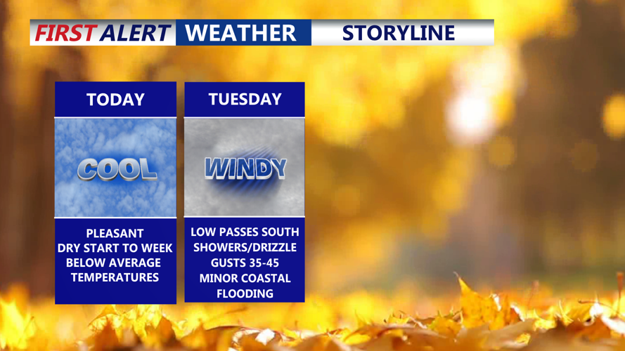


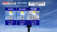


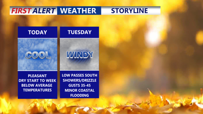
DELMARVA -- An expansive area of high pressure centered to the north will continue to dominate Delmarva’s weather through Monday, bringing dry conditions and partly cloudy skies, more clouds southern reaches of the peninsula. The beaches will experience gusty northeast winds up to 25 mph, while inland temperatures will stay mild, reaching the upper 50s to low 60s.

Partly cloudy skies, winds out of the northeast gusting 20-25 mph.
By Monday night, a developing low-pressure system off the Carolinas will begin to influence the region. Winds will strengthen from the northeast, particularly along the coast and over marine waters, and low clouds are expected to develop across the coastal plain. Temperatures will dip into the mid to upper 40s under mostly cloudy skies, with showers likely in southern Delmarva.

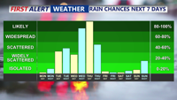
Two systems will impact the region, one Tue-Wed brining showers/drizzle and windy conditions, the next Wed PM-Thu, bringing heavier rain wind and possible thunder.
Through Tuesday and Wednesday, strong high pressure to the north and weak offshore low pressure will bring scattered showers through the peninsula, as onshore flow intensifies. Winds will remain moderate to strong, between 10 and 20 mph with gusts nearing 40 mph near the coast. Highs remaining in the upper 50s to low 60s.
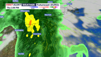
Conditions will turn more active Thursday as low pressure tracks across the Tennessee Valley and deepens near the Great Lakes. The system could bring widespread rainfall, gusty winds, and even a chance for thunder across the region. Rainfall totals between one and two inches are possible, especially near coastal areas, with higher amounts possible. Temperatures will be mild ahead of the front, ranging from the upper 50s northwest to the upper 60s southeast, with winds gusting 20 to 30 mph.

Low pressure will pass to our west Thursday, rain heavy at times and a rumble of thunder possible Thursday. Could see up to 1-2" of rain.
By Friday, the storm system will move north, allowing drier and cooler air to settle over Delmarva. Skies will turn partly cloudy, though gusty winds of 15 to 25 mph may persist. Highs will stay in the 50s and low 60s—ideal for any early Halloween festivities.
The first weekend of November looks seasonably mild and mostly dry, with daytime highs in the low 60s and lows in the upper 30s to low 40s. Northern and western areas could see lows dip into the low 30s. While much of the weekend should remain dry, a few showers may develop later Sunday as an upper-level trough lingers over the region.