


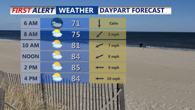
DELMARVA -- Friday will be slightly cooler than Thursday across Delmarva as an easterly flow keeps coastal highs in the low to mid-80s, with inland and Eastern Shore areas reaching the mid-80s. Skies will feature a mix of sun and clouds, and while most locations will stay dry, an isolated shower cannot be ruled out. Overnight lows will fall into the upper 60s, with coastal areas holding near 70 degrees.

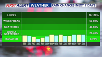
Isolated shower today, no big rain chances through the next 7 days.
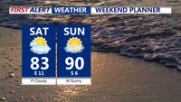
Heading into the weekend, a stalled front will linger over the Mid-Atlantic while high pressure builds south from Quebec into the Canadian Maritimes and the Northeast. This will maintain an onshore breeze Saturday before winds turn more westerly later in the day as high pressure slides offshore. Dew points will drop slightly into the upper 60s to around 70, making for a less humid feel, though temperatures will still climb into the 80s.

Really nice weekend shaping up on Delmarva, mostly sunny, highs low to mid 80s Saturday, turns hotter Sunday highs near 90.
Sunday will turn warmer and more humid ahead of an approaching cold front. Highs will reach the 80s to near 90, with heat index values in the mid-90s. Scattered afternoon and evening showers or thunderstorms could develop, although widespread activity will be limited.
By Monday, a stronger cold front will cross the region, ushering in noticeably cooler and drier air. Highs early next week will be in the low 80s, with dew points settling into the 60s. While most days will be dry, a few afternoon showers or thunderstorms could pop up, especially midweek as the front stalls nearby and weak disturbances pass through.
Tropical Update: Erin is forecast to become a hurricane Friday and a major hurricane by the end of the weekend. The system is expect to curve northward early next week. Still uncertainties on how west the system will track. One thing is growing certain, dangerous swells and rip currents will develop mid to late week along the Delmarva coastline.