


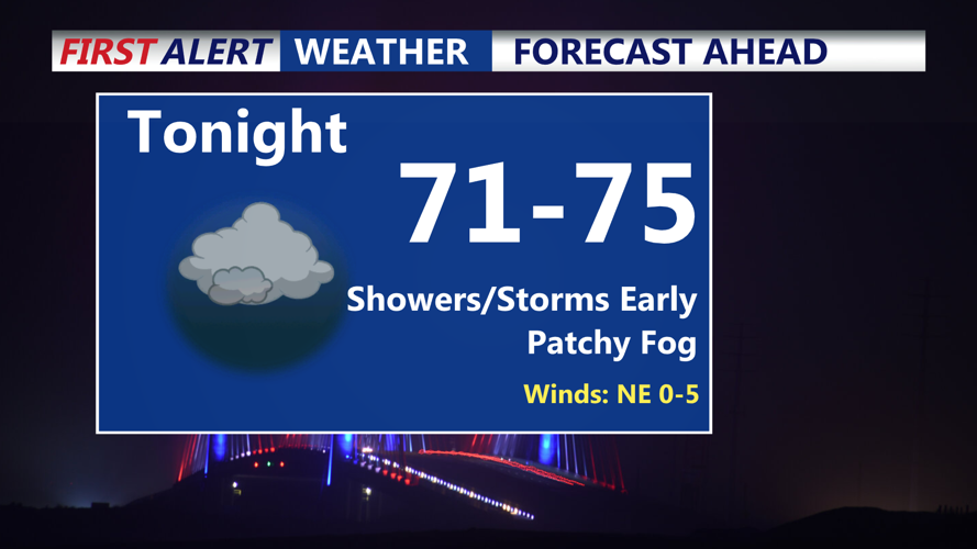


DELMARVA -- Any scattered showers and downpours will be ending through the evening. Expect partly cloudy skies across Delmarva as a cold front settles just south of the region, where it will stall through the weekend. High pressure over Quebec and New England will begin to build southward, maintaining an onshore flow. Overnight lows will dip into the low 70s, and while patchy fog is possible in areas that saw rain today.

Showers and storms early give way to a muggy night with some fog developing.
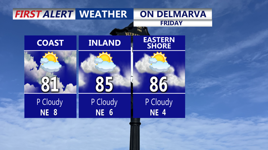
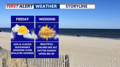
Friday will feature a mix of sun and clouds, with an easterly breeze and highs in the low to mid-80s. The air will remain humid, and an isolated shower can’t be ruled out, though most of the day is expected to stay dry. The nearby cold front will linger, while high pressure over eastern Canada continues to extend toward the Mid-Atlantic.

Friday will be a pleasant day, can't completely rule out the possibility of an isolated shower.
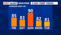
Saturday will bring a shift in winds to the west as high pressure slides offshore. Dew points will drop slightly into the upper 60s to near 70, offering a touch of relief from the humidity. Highs will remain in the low to mid 80s. Lows Saturday night will dip into the upper 60s, staying near 70 along the coast.

Sunday looks to be the hottest day of the next 5, drier air moves in early next week behind the cold front.
Sunday will be warm and humid ahead of another cold front, with highs climbing into the 80s to near 90 and heat index values reaching the mid-90s. Scattered afternoon and evening showers or thunderstorms are possible, though upper-level support appears limited.
A stronger cold front is set to arrive Monday, ushering in cooler and drier air for the first half of next week. Highs will settle in the low 80s, with dew points in the 60s. While most days will be dry, occasional showers or storms remain possible as the front stalls nearby and weak disturbances move through midweek. Cooler temperatures are expected through next week.
Tropical Update: Tropical Storm Erin is forecast to become a hurricane by Friday and a major hurricane by the end of the weekend. The system is expect to curve northward early next week. Still uncertainties on how west the system will track. One thing is growing certain, dangerous swells and rip currents will develop mid to late week along the Delmarva coastline.
