


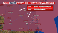


DELMARVA -- Stay Weather Aware — Dangerous storms are possible
Primary threats include, torrential downpours, damaging wind gusts, large hail, isolated tornadoes (brief, but not ruled out)
Warm and muggy conditions have settled over the region as a warm front lifts northward. Partial sunshine may break through in the afternoon, which could further destabilize the atmosphere and trigger a second round of strong to severe thunderstorms later Friday and into the evening.
While storms may taper off slightly Friday evening, the unsettled pattern continues. Low clouds, mist, and fog may redevelop overnight. Another round of storms—potentially a mesoscale convective system (MCS) tied to a broader weather disturbance—could arrive late Friday night into Saturday morning. There is uncertainty with this setup, will continue to monitor.
By Saturday, Delmarva will be under the influence of a strong cold front sweeping in from the west. Storms may re-develop in the afternoon, particularly if morning clouds and any lingering MCS activity diminish.

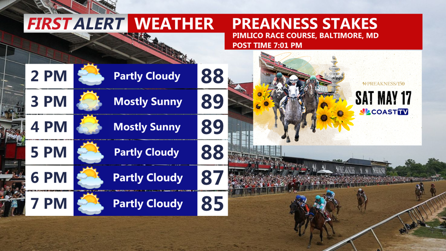
Headed to Pimlico, looking partly cloudy warm and muggy with highs in the upper 80s.
Forecast models are highlighting. Moderate instability, sufficient wind shear, potential for damaging wind gusts, hail, and even a brief tornado. Although there is still uncertainty how this will develop.
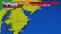
The Storm Prediction Center’s Slight Risk designation (Level 2 of 5) for severe weather across the area.

Risk for some severe storms Friday Night-Saturday.

