


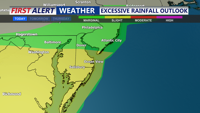

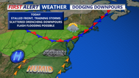


DELMARVA -- A stalled out stationary front continues to be the focus for isolated to scattered showers and thunderstorms the next couple of days. Watch for locally heavy rain and localized flash flooding, especially in low lying areas and poor drainage spots.

The best chance of showers and storms occurs later this afternoon and evening. High temperatures will be in the mid 80s inland, with 70s and 80s at the coast. This evening showers and storms diminish, otherwise expect partly cloudy and muggy condition overnight, with some fog possible late. Lows in the 70s.

An upper level ridge building in from the southwest will gradually reduce the coverage of storms, but forecast confidence remains low on exactly when this drier trend could take hold. Rainfall amounts over the next few days could exceed 3 inches in some places.

For Wednesday, expect a mix of sun and clouds with another chance for scattered to isolated storms. Some with heavy rain that could cause local flooding in some spots. Highs in the mid to upper 90s.

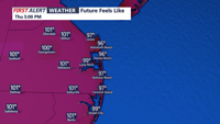
Looking beyond midweek, the focus shifts to intensifying heat and humidity. Warm air advection from the southwest will send heat index values into the lower triple digits by Thursday, creating potentially dangerous conditions for outdoor activities. The oppressive heat lingers into Friday, with highs in the low 90s, and triple digit heat indices.
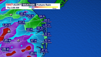
By the end of the week, the next front is forecast to approach the region. This boundary could serve as a trigger for more widespread showers and thunderstorms, although the timing and strength remain uncertain. While severe storms are not strongly signaled, any front arriving during peak heating could marginally increase the risk for damaging winds.