


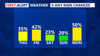

DELMARVA - A humid, unsettled weather pattern is expected to grip Sussex County from early Thursday through early Saturday, bringing repeated rounds of showers and thunderstorms.
Forecasters say a stalled frontal boundary will linger across the region, drawing in abundant tropical moisture. After some areas see lingering overnight storms Wednesday into early Thursday, conditions may briefly improve Thursday morning. However, another wave of showers and thunderstorms is expected to develop by Thursday afternoon and persist into the evening.
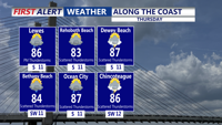
High dew points in the low to mid-70s will combine with afternoon highs in the low to mid-80s, resulting in heat index values that could approach the mid-90s. With moisture levels remaining high, any thunderstorms will be capable of producing locally heavy rainfall and gusty winds.
The risk of flash flooding will remain a concern, especially in areas that receive multiple rounds of storms. While no widespread severe weather is currently forecast, the National Weather Service warns that localized damaging wind gusts and brief torrential downpours will be possible through Thursday night.
By Friday, the pattern is forecast to repeat yet again. Additional disturbances will move across the Mid-Atlantic, triggering afternoon and evening thunderstorms. Temperatures will remain seasonable, with highs in the mid-80s and overnight lows staying warm in the lower 70s.
While showers and storms will not be continuous, forecasters emphasize that multiple rounds are likely, with the most active periods during peak heating each afternoon and evening. Any areas that experience repeated storms could see pockets of flooding, particularly in poorly drained spots and near small creeks.
Conditions are expected to gradually improve early Saturday as the frontal boundary begins to drift south and weaken. However, warm and humid air will remain in place, and scattered storms may still develop during the day Saturday before drier air arrives later in the weekend.
Residents are urged to monitor updated forecasts and remain cautious when driving through heavy rain or ponding water on roads.