



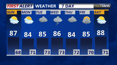

DELMARVA - Saturday will start with a mix of sun and high clouds as the day progresses. A shortwave trough will approach the region, bringing an increase in cloud cover by the afternoon. The stalled frontal boundary to the south will begin to lift northward, raising the chance for some showers and possibly isolated thunderstorms by mid to late afternoon. The greatest chances, around 25-40%, will be across Delmarva and southern New Jersey, with eastern Pennsylvania seeing a 20-30% chance. Most of the region will remain dry and seasonable, with afternoon highs in the low to mid 80s. Dew points will creep back into the low to mid 60s, making it feel more humid.
Saturday Night: As the shortwave trough passes through, the chance for convection will increase, although overnight instability might limit the intensity of the storms. The forecast calls for a 20-40% chance of precipitation, with isolated showers and thunderstorms possible. Temperatures will remain mild, with lows in the mid 60s to low 70s under mostly cloudy skies.
Sunday: Sunday will see the return of zonal flow, bringing more sunshine compared to Saturday. However, some isolated lingering convection is possible across southern Delmarva, with the boundary still in the vicinity. The day will be mostly dry, with highs ranging from 85 to 90 degrees, making it the warmest day of the weekend. Dew points will stay in the 60s, maintaining the humid conditions. Severe thunderstorms are unlikely, but any storms that do develop may bring gusty winds and heavy downpours.
Sunday Night: Conditions will remain tranquil through Sunday night, with mostly cloudy skies and mild temperatures. Lows will be around 73 degrees, and there will be a continuing chance of isolated showers and thunderstorms.
Prepare for a warm and increasingly humid weekend, with a heightened risk of showers and thunderstorms, especially from Saturday afternoon into Sunday. Stay updated with the latest forecasts as weather conditions can change rapidly.
