


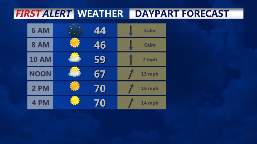


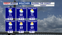

DELMARVA - Sussex County will enjoy a mild and breezy Tuesday before a cold front arrives late in the evening, bringing scattered showers and cooler air by early Wednesday morning.
After a calm start to the day under partly sunny skies, southwest winds will increase Tuesday afternoon ahead of the approaching front. Gusts could reach 20 mph at times as warmer air moves into the region, pushing afternoon highs close to 70 degrees.
Clouds will thicken late in the day, but most of Sussex County should remain dry until after sunset. By Tuesday night, a cold front associated with a low-pressure system tracking near the Great Lakes will move through, bringing isolated to scattered showers across the region. Rainfall is expected to be light, but wet roads and reduced visibility could affect early Wednesday travel.
Behind the front, winds will shift to the northwest and strengthen, with gusts up to 25 mph possible by Wednesday morning. Cooler, drier air will follow, dropping temperatures into the 40s overnight and setting up a much cooler day ahead.
By sunrise Wednesday, showers will taper off, and skies will begin to clear. Highs Wednesday afternoon will stay in the mid-50s to mid-60s as brisk northwest winds continue to usher in a fall-like air mass.