


DELMARVA -- Saturday brought warm and cloudy conditions across the peninsula, with highs reaching into the upper 70s and even touching 80 degrees in some spots. The mild trend continues Saturday night with lows only dropping into the upper 50s to low 60s—more in line with the region’s average daytime highs for late March.

Another mild day with mostly cloudy skies.
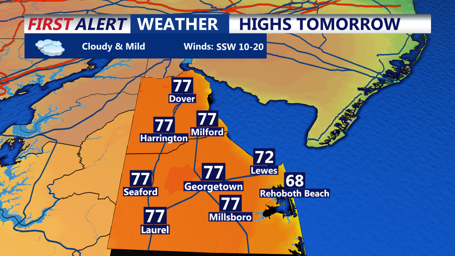
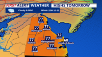
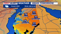
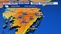
Sunday will be another unseasonably warm day on Delmarva, with highs in the mid to upper 70s inland and upper 60s to low 70s along the coast under mostly cloudy skies.

Highs in the mid to upper 70s, cooler along the coast.

Mid 70s on the Eastern Shore Sunday.
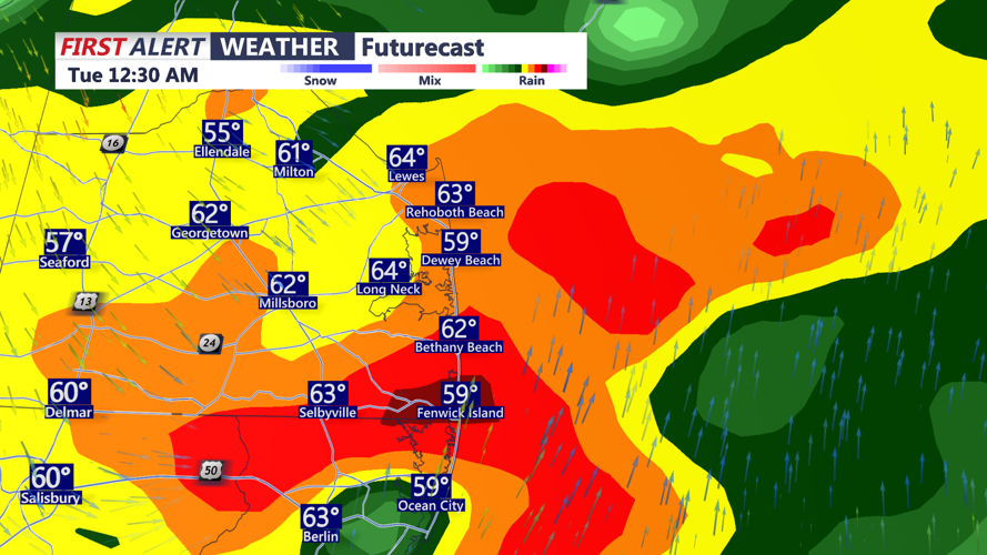
A stalled front draped across the region will slowly lift northward as a warm front by Sunday night. While most areas will remain dry, a few isolated showers may develop near the front overnight. Temperatures will be non-diurnal, meaning they will gradually rise overnight, with early Monday morning lows in the low 60s.
The bigger weather story unfolds Monday as a strong cold front approaches from the northwest. A damp and mild start with a few showers. It will be another warm day ahead of the front with highs in the mid to upper 70s, and quite breezy with gusts to 40 mph It looks like the heaviest rain and thunderstorms hold off until evening and later at night.

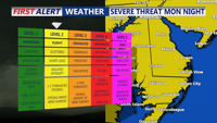
Slight risk (2 of 5) for severe storms Monday night, damaging winds is the primary threat.
The Storm Prediction Center has placed the entire Delmarva peninsula under a slight risk for severe weather, with damaging wind gusts the primary concern. Pre-frontal showers or storms could also pop up during the day. Skies will remain mostly cloudy, which could limit instability, but a potent combination of wind shear and atmospheric moisture may still support severe storm development.

Strong cold front pushing through Monday night-early Tuesday morning.
Rainfall totals between 0.75 and 1.25 inches are likely, with locally higher amounts possible. Despite the region’s ongoing drought, heavy rainfall rates could lead to localized urban flooding.
Behind the front, cooler and drier air will sweep in overnight, dropping temperatures into the 40s/50s by Tuesday morning.
High pressure builds Tuesday and Wednesday, bringing gusty northwest winds early Tuesday and gradually clearing skies. Highs both days will be seasonable, ranging from the upper 40s to upper 50s. By Tuesday night, some inland areas could flirt with freezing temperatures, prompting a low potential for frost or freeze advisories—especially in southern parts of Delmarva where the growing season officially begins April 1.
The calm won't last long, however. Another unsettled weather pattern is forecast to take hold late in the week, with multiple rounds of rain possible from Thursday through Saturday. While exact timing remains uncertain, forecasters expect warming temperatures in the 60s and 70s during the latter half of the week.